
Lord Howe Island sits in the Tasman Sea, a crescent of volcanic rock, palm forest and lagoon roughly 600 kilometres east of Port Macquarie and about 700 kilometres north-east of Sydney. It is not an Australian external territory like Norfolk Island or Christmas Island. It is part of New South Wales — brought within the colony’s boundaries by Imperial statute in 1855, still under NSW law today, and run day to day by a statutory Board that answers to a NSW minister. That constitutional fact shapes almost everything that follows: land tenure, elections, tourism limits, and the way World Heritage duties sit on a small island community.
This page gathers the documented story from volcanic origins and the 1788 sighting by HMS Supply, through whaling-era settlement, Kentia palms, flying boats and the 1974 airstrip, to the Lord Howe Island Act 1953, World Heritage listing in 1982, rodent eradication, and the pressures that still sit on the southernmost coral reef.
Volcanic island group and Ball’s Pyramid


The Lord Howe Island Group is the eroded remnant of a large shield volcano. Federal heritage material published by the Department of Climate Change, Energy, the Environment and Water (DCCEEW) summarises the geology in plain terms: nearly seven million years ago, movement of the underwater Lord Howe Rise helped build a shield volcano on its western edge; over time the sea removed about ninety per cent of that volcano, leaving the islands that remain. The main island is dominated at its southern end by Mount Gower (about 875 metres) and Mount Lidgbird (about 777 metres), with a lowland saddle and settlement area between the northern hills and those peaks.


Offshore lie the Admiralty Islands, the Mutton Bird Islands, smaller stacks and reefs, and — south-east of the main island — Ball’s Pyramid, a sheer volcanic pinnacle often described as the tallest volcanic sea stack of its kind. UNESCO and Australian heritage statements treat the whole group, including reefs and surrounding marine environments, as one World Heritage property. The terrestrial area is only about 1,540 hectares; the inscribed property including marine waters is far larger (on the order of 146,300 hectares in the Outstanding Universal Value summary).
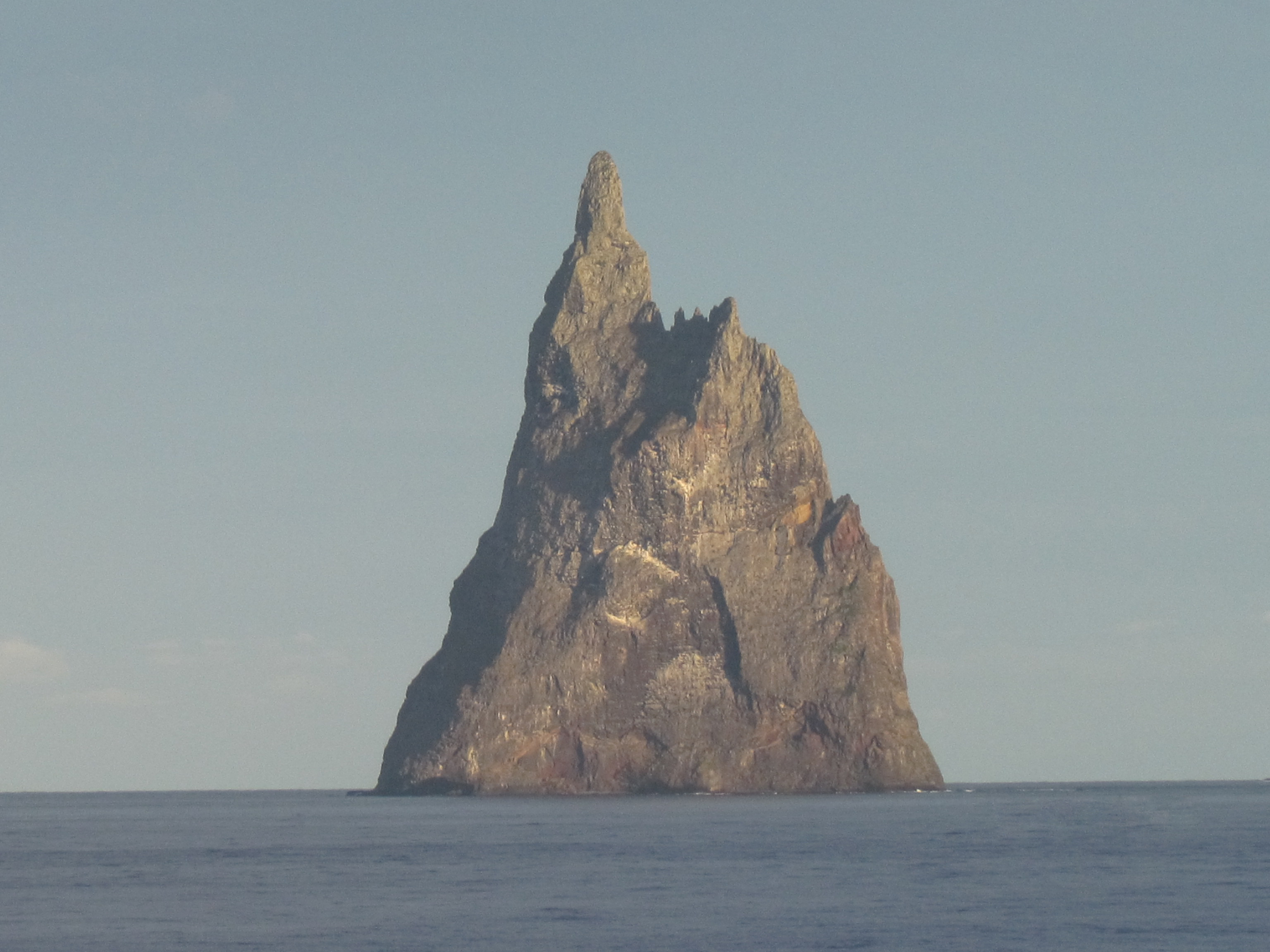


About three-quarters of the land is managed as the Permanent Park Preserve under the Lord Howe Island Act. The preserve takes in the northern and southern mountains of the main island, the offshore islets, and Ball’s Pyramid. That park status matters later in the legal story: it is not a mainland national park created under a different Act so much as a preserve created inside Lord Howe’s own statute, with the Board required to manage it in a way aligned with national-park standards.
Before 1788: what is and is not documented
There is no documented permanent human community on Lord Howe Island before European sighting in 1788. Museum and heritage accounts treat the island as uninhabited when Ball’s party arrived. That is not the same as claiming no human being ever touched the place. Pacific voyaging left traces on many islands; for Lord Howe the careful wording is that permanent pre-1788 settlement has not been demonstrated in the archaeological and historical record so far assembled. Where older speculation appears in secondary writing, it should be read as speculation unless archaeology or contemporary records say otherwise.
Discovery, 17 February 1788

On 17 February 1788 Lieutenant Henry Lidgbird Ball, commanding the First Fleet armed tender HMS Supply, sighted the island while sailing from Sydney Cove to found the Norfolk Island settlement. The Lord Howe Island Museum’s discovery notes, written by naturalist and local historian Ian Hutton, give the sequence clearly: sighting on the outward Norfolk voyage; landing on 13 March 1788 on the return, when men from Supply came ashore to explore and claim the island in the name of the Colony of New South Wales.


Ball named the island after Lord Howe — Richard Howe, then First Lord of the Admiralty. Mount Lidgbird and Ball’s Pyramid take Ball’s own names. Other First Fleet ships visited the same year; sailors left diary notes and sketches of birds that had never met people with guns. Those early natural-history images matter because several of the tame island birds would not survive the nineteenth century.


The white swamphen (Porphyrio albus), known from early voyage illustrations including Arthur Bowes Smyth’s 1788 journal drawing, is among the island birds that later disappeared. “Discovery” for the British state was also the opening of a hunting ground. Settlement would deepen that pressure.
Whaling stopover and settlement from the 1830s
From about 1800 the island became a known provisioning stop for whaling and Pacific trading ships needing water, vegetables, fish and meat. Permanent settlement followed in the early 1830s. The Lord Howe Island Museum’s settlement account names three men — Ashdown, Bishop and Chapman — arriving from New Zealand on the barque Caroline with Māori wives and two Māori boys, settling at Hunter Bay (Old Settlement) to supply ships. The museum dates that arrival to 1833; other accounts date it to 1834.
In 1841 Captain Owen Poole and Richard Dawson bought the earlier settlers’ holdings. Other families followed, including Thomas and Margaret Andrews in 1842. Dr John Foulis arrived in 1844. In 1847, after failing to secure a lease from the NSW Government, Poole, Dawson and Foulis abandoned their venture; employees could leave or stay as independent settlers. Andrews descendants through the Nichols line remain part of island genealogy. In 1853 Nathan Chase Thompson, a rigger from the American whale ship Belle, settled with partners and women from the Gilbert Islands (Kiribati). Later Thompson–Wilson marriages knit much of the modern island kinship network. By the 1880s the museum describes a small, stable, multicultural community.
Life was market gardening, fishing, trade with passing ships, and hard work at the edge of the Pacific. Introduced pigs and goats, useful as food, later went wild and damaged habitat — a pattern repeated on many islands. Endemic birds that had no fear of people were easy to kill. Extinction and decline are part of the settlement record, not a side note.
Part of New South Wales, not an external territory
The 1855 boundary wording
Lord Howe Island is often described as a dependency of New South Wales — a phrase that captures its distance from the mainland and its special administrative arrangements. Legally, though, the island is part of New South Wales itself rather than an Australian external territory. The Lord Howe Island Board’s plain-language guides put the point directly: the island “was included as part of the Colony of NSW in 1855 and the laws of NSW continue to apply on the Island today.”
The Imperial New South Wales Constitution Act 1855 (18 & 19 Vict. c. 54), given Royal Assent on 16 July 1855, set the colony’s limits. Section XLVI expressly included “Lord Howe Island, being in or about the Latitude of Thirty-one Degrees Thirty Minutes South and the One hundred and fifty-ninth Degree of East Longitude, reckoning from the said Meridian of Greenwich,” within the boundaries of New South Wales. That clause is why the island sits inside the State’s legal map even though it lies east of the ordinary mainland longitude limit stated in the same section.
So Lord Howe is inside New South Wales. It is not administered as an Australian external territory under Commonwealth territories law in the way Norfolk Island has been. NSW Acts apply generally, with special island legislation layered on top. The Board’s Information Sheet 2 explains that NSW laws apply as they do elsewhere in the State, except where they do not apply or apply in a modified way; the Crown Lands Act regime that governs much mainland Crown land does not govern Lord Howe in the ordinary way because the Lord Howe Island Act 1953 occupies that field.
Early officials, Forest Reserve and the first Board
Distance meant light government at first. The museum’s administration notes say the island was proclaimed a Forest Reserve and that Captain Armstrong arrived in 1878 as the first resident government official — forest ranger, magistrate, postmaster and registrar rolled into one. Conflict with some residents led to inquiry and his removal, later tempered by parliamentary committee findings. Visiting magistrates followed; a Government House for officials was built about 1890. Through the late nineteenth century the island remained a tiny, remote settlement whose practical contact with Sydney came by sailing vessel and later steamship rather than by any continuous mainland bureaucracy.
Royal Commission inquiries into island affairs around 1911–12, tied in part to palm-seed marketing, led to a Board of Control appointed in 1913: three mainland public servants in Sydney, advised by a local residents’ committee. The Board’s early powers sat in the terms of appointment rather than a dedicated Act. For decades residents held only permissive occupancies over Crown land. Palm-seed bonuses helped fund local services until that trade slumped in the Second World War, while postwar air travel increased tourism pressure.
Lord Howe Island Act 1953
The Lord Howe Island Act 1953 created a statutory authority to care for, control and manage the island, its trade and the welfare of residents, subject to the NSW minister’s direction and control (except when making a report or recommendation). The 1953 version set up a mainland-appointed Board and an elected Island Committee. It confirmed that all land remained vested in the Crown — no freehold — and provided for leases in perpetuity (originally up to five acres) for Islanders’ homes, plus shorter special leases for agriculture and similar uses. Transfer and price rules were designed, at Islanders’ urging, to stop homes being priced out of local hands.
Amendments in 1981–82 restructured representation so elected Islanders sat on the Board itself, abolished the separate Island Committee, adjusted who counted as an “Islander,” and dedicated the northern and southern ends of the main island and the adjacent small islands, including Ball’s Pyramid, as a permanent park reserve. Further 2003–04 amendments expanded the Board to seven members — today’s pattern of four Islanders elected by the community and three members appointed by the minister — strengthened governance standards along local-government lines, promoted ecologically sustainable development, and ended the Board’s old monopoly on Kentia gathering and sale.
Detailed election, lease, environment, anchoring and alcohol rules are set out in regulations under the Act. The Lord Howe Island Board identifies the Lord Howe Island Regulation 2014 as the instrument that gives effect to those provisions.
Who is an Islander, and who may lease
Board Information Sheets summarise how “Islander” status works under the Act: it carries priority for leases and eligibility for elected Board seats. Broadly, a person may qualify by ten years’ continuous residence as a genuine home, or under older “1981” pathways tied to pre-1954 permissive occupancy families. The Minister, on Board recommendation, can confer status in special cases. Perpetual leases stay Crown leases, not freehold titles. Non-Islanders can take a lease only in limited circumstances, typically where no Islander is willing and able. Inheritance rules favour Islanders and lineal descendants; the Board keeps a public register of leases. Those rules help explain why Lord Howe still feels like a closed land market even while it welcomes capped tourism.
As described on the Board’s About page, the Board remains responsible to the NSW Minister for the Environment, with staff employed under the NSW Government and a chief executive on the island. It performs local-government-like functions — roads, power, aerodrome, planning consents, business licensing, biosecurity controls on animals, plants and vehicles — with extra custodial duties over Crown land and tourism that go beyond an ordinary mainland council.
Kentia palms, ships and scientific visitors


Four palm species are native to Lord Howe. Howea forsteriana, the Kentia or thatch palm, became a global indoor plant. From about 1870 seed exports fed nurseries in Europe, America and Australia. The museum notes that houses were thatched with it locally, while overseas it filled hotel lobbies and parlours — the Savoy in London appears in the museum’s palm-industry retelling. Seed marketing disputes helped trigger the early Board. After the Second World War the trade shifted; by 1981 seed exports had given way to live seedlings, and the Board nursery later passed to private operators. The palm story is both livelihood and landscape: pure stands of Howea still shape the lowland forest.


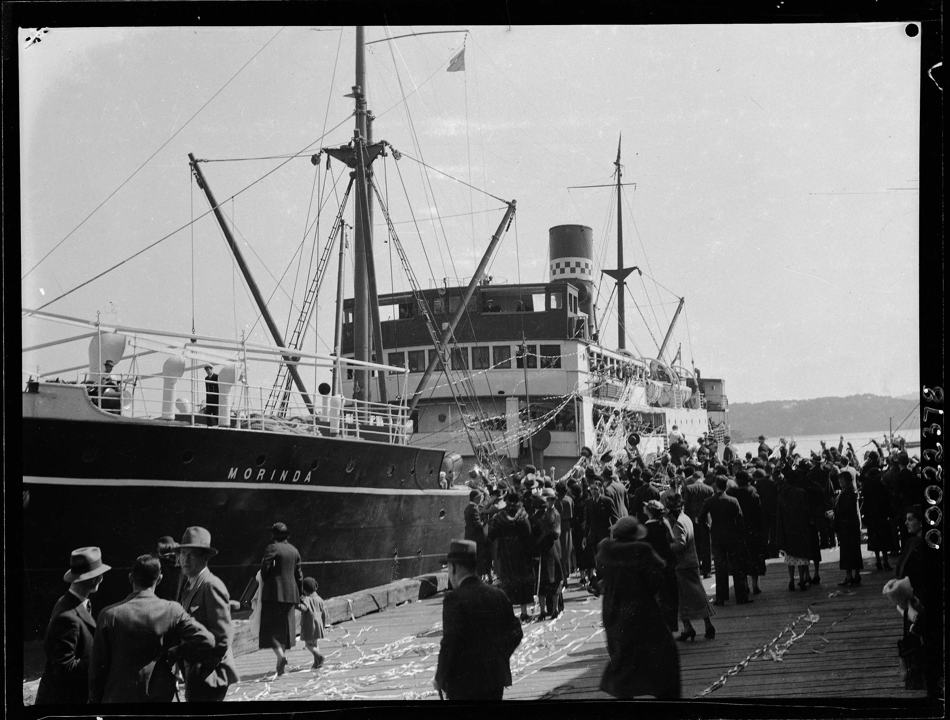
Scientific visitors kept coming. Australian Museum ichthyologist Allan McCulloch filmed and collected on the island in the early twentieth century; Frank Hurley’s 1921 photograph of McCulloch with a cine camera on Mount Gower is one of the clearer period images of that scientific traffic. Later generations of biologists would chase woodhens, phasmids, land snails and reef ecology. Shipping underpinned it all: Burns Philp steamers such as SS Morinda (1932–52 in museum notes) and, in recent decades, the Island Trader freight run from Port Macquarie.


Flying boats, war links and the 1974 airstrip
Francis Chichester landed on Lord Howe Island for fuel in 1931 during his solo east–west Tasman crossing in the Gypsy Moth seaplane Madam Elijah. Island-hopping via Norfolk Island and Lord Howe was part of the planned route because the aircraft could not carry enough fuel for a nonstop crossing. Overnight a storm flipped the seaplane at its lagoon mooring; with local help he spent about nine weeks rebuilding engine and wings before flying on to Jervis Bay. The Lord Howe Island Museum’s aviation notes tell the story in those terms.


During the Second World War the RAAF operated Catalina flying boats to the island in connection with a meteorological station and radio base.
Commercial flying boats followed. Trans Oceanic Airways began scheduled passenger services in 1947; Qantas followed a few months later using Catalina and Sandringham aircraft; Ansett took over in the early 1950s and ran Short Sandringhams from Rose Bay on Sydney Harbour. Aircraft such as Beachcomber (VH-BRC) and Islander, each able to carry about forty-two passengers on the museum’s account, were timed to tide for lagoon landings, with up to six flights a week in the busy season. The three-hour trip from Sydney Harbour became the romance of postwar island travel until economics and ageing airframes forced a change. The last Ansett Rose Bay–Lord Howe passenger service ran on 10 September 1974. Beachcomber survives today at Solent Sky Museum in Southampton, still finished in Ansett colours.


By 1974 the operation had become uneconomic. After years of debate, Australian Army engineers built a roughly 1,000-metre airstrip at the former Mosely Park swamp. Construction plant arrived by Navy landing craft in early March 1974; Army personnel themselves still came in by flying boat. The first landing on the new strip was a RAAF Caribou used for a medical evacuation. The last scheduled flying-boat passenger service followed on 10 September 1974, after which small land aircraft took over the link. In September 2024 the island marked fifty years since that construction, with Army and Navy veterans returning and presenting material to the museum. Today’s flights from the mainland are the ordinary door to a place that once arrived by sail, steamer and flying boat.


World Heritage, Permanent Park Preserve and Marine Park
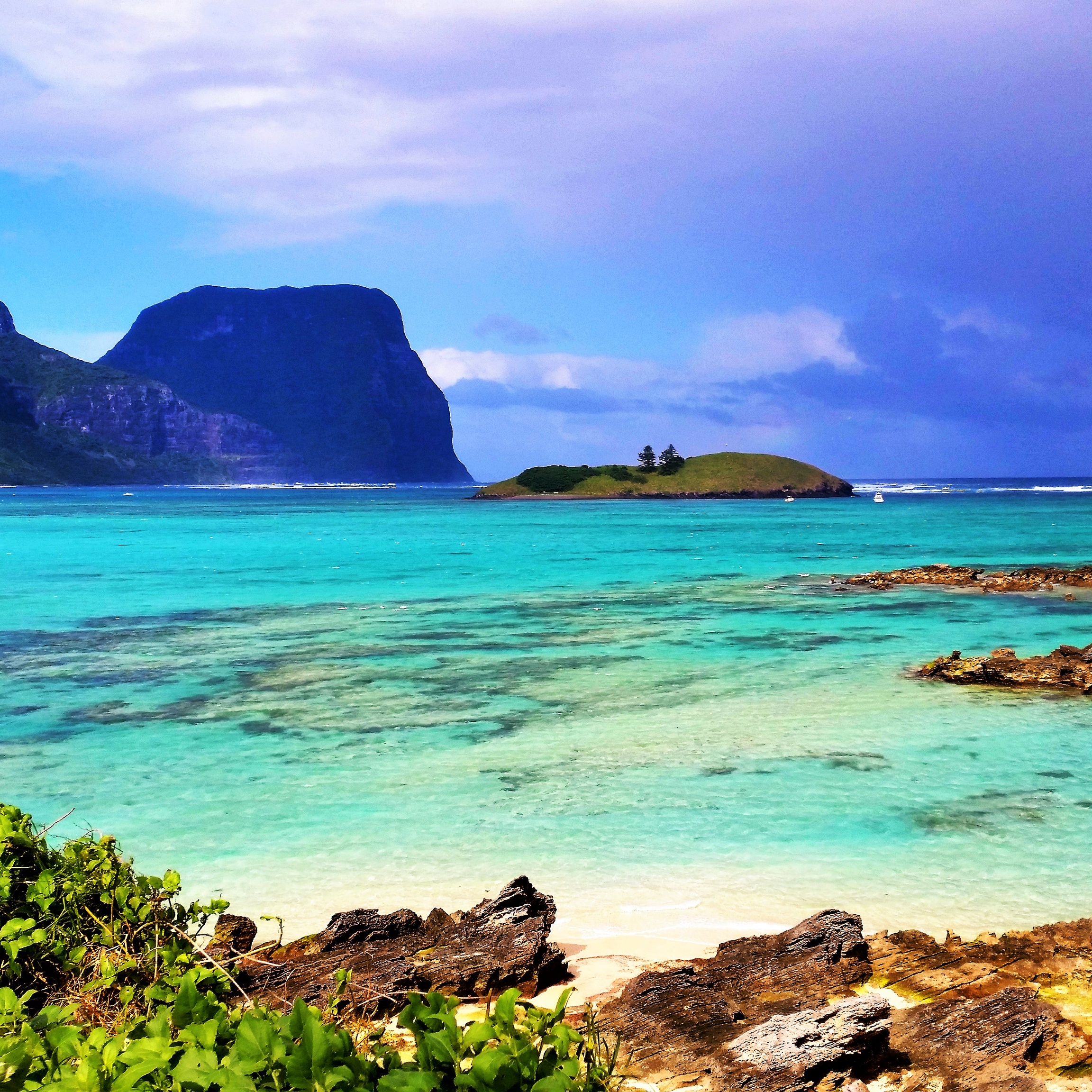

The Lord Howe Island Group was inscribed on the UNESCO World Heritage List in 1982 for natural criteria that stress spectacular volcanic scenery, the world’s most southerly true coral reef, high endemism, and outstanding habitat for threatened species. It entered Australia’s National Heritage List on 21 May 2007. Iconic species named in the Outstanding Universal Value text include the flightless Lord Howe woodhen and the Lord Howe Island stick insect (phasmid), feared extinct until rediscovery on Ball’s Pyramid. The listing covers the main island, Ball’s Pyramid, associated islets and surrounding marine areas as one property — a reminder that the legal island group and the ecological island group are larger than the settlement saddle where most visitors sleep.


NSW created marine park protection in the late 1990s (heritage summaries commonly cite 1998–99 for the State marine park). Commonwealth waters beyond three nautical miles later gained additional marine reserve protection. Board Information Sheet 2 notes NSW waters to three nautical miles and Commonwealth waters from three to twelve, with the Environment Protection and Biodiversity Conservation Act 1999 applying to World Heritage impacts. Climbing on Ball’s Pyramid is tightly controlled; recent World Heritage outlook writing treats scientific and management access as the usual basis for permits.
Woodhen, phasmid, rats and recovery


The woodhen was driven to a handful of breeding pairs by the late twentieth century. Captive breeding and predator control pulled it back from the brink; federal heritage text still remembered populations around a couple of hundred in older summaries. The Board’s post-eradication ecological reporting is more recent and more hopeful: the annual survey in late 2024 counted at least 1,638 woodhens, up from 1,147 in 2022 and from 208 birds in 2019 when birds were released from captive management around the Rodent Eradication Project.


Black rats reached the island after the Makambo grounding at Ned’s Beach in 1918 — museum and conservation accounts agree on that wreck as the entry point. Rats are implicated in the extinction of five endemic birds, many invertebrates and some plants. The phasmid vanished from the main island; climbers later found dead insects on Ball’s Pyramid, and live insects were confirmed there in 2001. Captive breeding (notably at Melbourne Zoo and partner institutions) kept a safety population. In March 2026 ABC News reported new colony finds on Ball’s Pyramid and public discussion of possible reintroduction to remote parts of the Permanent Park Preserve, after rodent clearance on the main island.
Mice were present from the nineteenth century; rats from 1918. Control schemes never finished the job. In mid-2019 the Board ran a whole-island eradication using aerial and ground baiting, with woodhens and currawongs held in captivity for protection. The Board now states that the Rodent Eradication Project has been formally completed, with a 2025 final report and lessons-learned package. A 2023 “Checkpoint” detection program, reviewed with New Zealand’s Island Eradication Advisory Group, found no live rodents after more than two years without detections. An earlier post-baiting detection of rats in 2021 triggered an intensive response; vigilance and biosecurity remain permanent duties. Board ecological notes also record rediscoveries such as the Lord Howe wood-feeding cockroach (2022) and critically endangered land snails long thought gone.
Community, tourism cap and daily island life


A few hundred people live on the island year-round. Exact headcounts move with censuses and Board summaries; recent tourism planning material has used figures in the low-to-mid hundreds for permanent population. Kinship still runs through nineteenth-century settler lines, and many livelihoods sit in accommodation, tours, fishing, trades and Board employment.
Tourism is capped. The long-standing Board policy — repeated in the Lord Howe Island Tourism Association Destination Management Plan 2024–2034 and in the 2025 IUCN World Heritage Outlook — limits visitors to 400 people on the island at any one time. Combined with residents, that keeps the total human load low. Beds are limited; flights follow bookings. Bicycles beat cars; the speed limit is low. An environment levy helps fund conservation. The Destination Management Plan treats the cap as essential protection against overtourism, tying commercial growth to the same World Heritage and biosecurity constraints that shape Board decisions on leases and development.


Culture is practical and local: museum and hall events, walking tracks, lagoon swimming, palm forest, and the quiet that the visitor cap is meant to protect. Islander political voice runs through Board elections and lease debates more than through a separate mainland shire council. When governance or biosecurity rules tighten, disagreement is real — as it is in any small community.
Bleaching, biosecurity and pressures that remain
World Heritage status does not freeze the climate. ABC Mid North Coast reporting in August 2025 described Lord Howe’s February 2024 bleaching as the fourth and worst recorded there since 1998, with university researchers monitoring slow subtropical recovery while sea temperatures stayed above long-term summer averages for months. Tour operators who log lagoon temperatures have spoken publicly about stress on coral gardens. The 2025 IUCN outlook rated overall conservation prospects as good, praised the visitor cap and rodent work, and still flagged climate-driven bleaching, cloud-forest change, weeds, pathogens such as myrtle rust and Phytophthora, and biosecurity as ongoing concerns.
Getting people and cargo on and off a rodent-free World Heritage island means constant screening of fruit, plants, soil and vessels. The Board publishes pre-departure biosecurity guidance for visitors. Fresh incursions remain the nightmare scenario after a multi-year eradication. Coral bleaching and hotter summers are the slower emergency.
What Lord Howe shows about New South Wales


Lord Howe is a reminder that NSW is not only a coastal strip and inland plains. It includes a volcanic speck whose land law never allowed freehold, whose Board mixes elected Islanders with ministerial appointees, and whose global fame rests on birds, palms, a lagoon reef and a rock stack that sheltered an insect once thought extinct. People still reach for the word “dependency” when they want to stress distance and special arrangements; the statute book places the island inside New South Wales from 1855. The difference matters when people ask who makes the rules, who owns the ground, and why a visitor needs a booking and clean biosecurity habits before stepping onto the jetty.
Sources
- Lord Howe Island Board — About the Board
- LHIB Information Sheet 1 — History of the Lord Howe Island Act 1953 (PDF)
- LHIB Information Sheet 2 — NSW and Commonwealth Laws on Lord Howe Island (PDF)
- LHIB Information Sheet 3 — Owning and Inheriting Land (PDF)
- LHIB Information Sheet 4 — Who is a Lord Howe Islander (PDF)
- New South Wales Constitution Act 1855 (UK) — boundary text including Lord Howe Island
- Lord Howe Island Act 1953 No 39 (NSW legislation site)
- Lord Howe Island Regulation 2014 (NSW legislation site)
- Lord Howe Island Museum — Discovery (Ian Hutton)
- Lord Howe Island Museum — Learn (settlement, administration, flying boats, palms, shipping)
- Lord Howe Island Museum — 50th anniversary of the airstrip
- DCCEEW — Lord Howe Island Group World Heritage place
- UNESCO World Heritage Centre — Lord Howe Island Group (ID 186)
- LHIB Rodent Eradication Project
- LHIB Ecological benefits (woodhen counts and rediscoveries)
- LHIB Checkpoint program 2023
- NSW DPI — Lord Howe Island Marine Park history and culture
- DCCEEW — Lord Howe Island phasmid
- ABC News — stick insect colonies on Ball’s Pyramid, 15 March 2026
- ABC News — coral bleaching research, 16 August 2025
- IUCN World Heritage Outlook — Lord Howe Island Group (2025)
- Lord Howe Island Tourism Association — Destination Management Plan 2024–2034 (PDF)
- LHIB Annual Report 2023–24 (PDF)
- NSW Land Registry Services — Lord Howe leases guidance