Search This Blog

Saturday, March 20, 2021

Christ Church - St Laurence - Anglican Church - 814 George Street - Haymarket - Railway Square - NSW

 Christ Church - St Laurence - Anglican Church - 814 George Street - Haymarket - Railway Square - NSW

Christ Church St Laurence stands at 812–814 George Street, Haymarket, right beside Railway Square and Central Station — the sandstone tower and spire you clock when you come in from the south. The parish dates from 1838. Bishop William Grant Broughton laid the foundation stone on New Year’s Day 1840 and consecrated the church on 10 September 1845: the first Anglican church in the city consecrated by a bishop, and still among the oldest Anglican church buildings in Sydney in continuous use.

Henry Robertson began the design; money troubles stalled the build before Edmund Blacket — later Sydney’s leading Gothic Revival architect and a long-serving churchwarden here — finished the interior (ceiling, tracery, fittings) and, in the 1850s, the tower and spire. The church became a centre of Anglo-Catholic worship in a diocese that leaned the other way — ritual, music and social action rather than a plain “preaching box.” A fire in 1905 damaged the interior; John Burcham Clamp led the restoration.

The church, hall and rectory group is on the NSW State Heritage Register. From George Street the spire still marks the railway-age city edge for anyone walking up from Central — a continuous place of worship from convict-era neighbours to the present.

Wedding Cake Island - Sydney Harbour - Port Jackson - New South Wales

 Wedding Cake Island - Sydney Harbour - Port Jackson - New South Wales 


Wedding Cake Island is a small rocky island located in the eastern part of Sydney Harbour, off the coast of Coogee Beach in New South Wales, Australia. Here's some information about Wedding Cake Island:

1. Name: Wedding Cake Island gets its name due to its distinctive shape, which is said to resemble a tiered wedding cake. The name is derived from its appearance when viewed from a distance, particularly from Coogee Beach or other vantage points along the coast.

2. Geological Formation: The island is a rocky outcrop that emerged due to geological processes over millions of years. It is composed of sandstone, which is a common rock type in the Sydney region.

3. Marine Life and Surrounding Area: The island is part of a marine reserve and is known for its diverse marine ecosystem. The surrounding waters are popular for snorkeling and diving due to the presence of coral reefs and a variety of fish and other marine creatures.

4. Access and Conservation: Wedding Cake Island is located offshore and can be seen from various coastal viewpoints. Access to the island itself is restricted to protect the local environment and wildlife. Visitors are not permitted to land on the island.

5. Importance to the Local Community: Wedding Cake Island is a significant landmark for the local community, particularly for residents and visitors of Coogee Beach. It adds to the natural beauty of the area and is often featured in photographs and artwork depicting the Sydney coastline.

6. Music Connection: Wedding Cake Island gained additional recognition through its association with the Australian rock band Midnight Oil. The band released a song titled "Wedding Cake Island" in 1979, which contributed to the island's cultural significance.

Wedding Cake Island is a distinctive geological feature and a notable landmark in Sydney Harbour. Its unique shape, marine biodiversity, and connection to the local community make it a memorable part of the coastal landscape.

Bare Island - La Perouse - Botany Bay - New South Wales

First geography check: Bare Island is not in Sydney Harbour. It is a low sandstone islet off the La Perouse headland on the northern shore of Botany Bay, linked to the mainland by a timber bridge — even though the blog’s harbour-islands title pattern put “Port Jackson” in the URL. Captain Cook’s 1770 journal noted “a small bare island” here as a navigational marker, and the English name stuck. The wider headland is part of the Gooriwal cultural landscape, with deep continuing connections for the La Perouse Aboriginal community (including Gweagal and Kameygal associations at European contact) to land and sea for food, work and recreation.

In the 1880s, colonial nerves about foreign naval attack fortified the rock. The fort was designed under imperial defence advice from Sir Peter Scratchley (with Gustave Morell) for the NSW Department of Public Works; Colonial Architect James Barnet is also associated with the works. Construction ran through the 1880s (commonly summarised 1881–1889). Decommissioned in the early twentieth century, from 1912 the fort served for decades as a war veterans’ home, with brief military reuse in the Second World War period.

Bare Island Fort is State Heritage listed and managed inside Kamay Botany Bay National Park / the La Perouse headland precinct by NPWS. It matters both as a near-intact late-nineteenth-century coastal defence work and as part of the living Aboriginal cultural landscape of La Perouse. Guided tours and headland walks are the usual way in — not a Port Jackson ferry hop.

Bare Island fort, La Perouse, Botany Bay.

Glebe Island - Sydney Harbour - Port Jackson - New South Wales

Glebe Island sits between White Bay, Johnstons Bay and Rozelle Bay — the inner western harbour’s working knuckle that most people now clock under the Anzac Bridge cables. The name glebe” recalls an early church land grant to First Fleet chaplain Richard Johnson; the rocky outcrop was later swapped and the name travelled with colonial church-land patterns. Aboriginal people of the western foreshores used these bays long before reclamation glued the former island to the Rozelle shoreline.

From the 1850s the place went industrial hard. Colonial Architect Edmund Blacket designed stone buildings for a public abattoir (opened around 1860), and a timber bridge soon linked the island to Pyrmont so meat could reach the city. The smells and effluent made it a notorious noxious trade; slaughtering later moved to Homebush. In the early twentieth century the Sydney Harbour Trust levelled and wharfed the rock. From 1921 tall concrete grain elevators and silos dominated the skyline as a bulk wheat terminal; later decades brought dry bulk cargoes and vehicle imports beside neighbouring White Bay.

Percy Allan’s 1903 Glebe Island swing bridge remains a landmark beside the later Anzac Bridge (opened 1995, renamed 1998). Though still called an “island,” the site has long been continuous with the mainland. It is a rare inner-harbour working-port landscape whose silos and wharves sit at the centre of Bays West / Bays Precinct fights over heritage, housing and public waterfront.

Glebe Island abattoirs, Sydney Harbour — historic photograph; State Library of NSW.

Snapper Island - Sydney Harbour - Port Jackson - New South Wales

 Snapper Island - Sydney Harbour - Port Jackson - New South Wales 

Snapper is the smallest island in Sydney Harbour — a ship-shaped scrap off Drummoyne and Birkenhead Point, sitting with Cockatoo and Spectacle in the western harbour. Early colonial wordlists record an Aboriginal name Ar-ra-re-agon. For most of the nineteenth century the rocky islet saw little permanent building; it was declared a public recreation reserve in the late 1870s and then barely visited.

World War I leased it for storage tied to Cockatoo Island Dockyard. The silhouette everyone notices today dates from 1931–32, when Leonard (Len) Forsythe of the Navy League had the rock blasted, levelled and expanded by reclamation into Training Depot “Sydney” (TS Sydney) for naval cadets. TS Sydney opened in November 1932. Seawalls were cut to suggest a ship’s bow and stern; buildings followed a deck-like plan a land-locked training ship pointed at Drummoyne. Parts salvaged from HMAS Sydney I when she was stripped at Cockatoo helped furnish the memorial idea.

TS Sydney ran as headquarters for Sydney Navy League units for decades. The island is on the Commonwealth Heritage List for Forsythe, the cadets, and that odd harbour skyline contribution. Structures have weathered; the museum collection moved (including to Spectacle and Garden Island) around 2006. Unlike Spectacle’s explosives complex, Snapper’s significance is cadet training, not magazines; access stays tightly managed.

Navy League / Sea Cadets at Snapper Island, Sydney (historical photograph).

Spectacle Island - Sydney Harbour - Port Jackson - New South Wales

 Spectacle Island - Sydney Harbour - Port Jackson - New South Wales 

Off Drummoyne, tucked with Cockatoo and Snapper in the old Hen and Chickens” group, Spectacle Island is the harbour’s quiet explosives cousin — the one most Sydneysiders only clock from a ferry or the Anzac Bridge approach. An Aboriginal name recorded in early colonial wordlists is Gong-ul. The European story is almost entirely powder and armament: Australia’s oldest naval explosives manufacturing and storage complex, with fabric from the 1860s still sitting on the rock.

From the early 1860s the colonial government put a gunpowder magazine here. Victorian Georgian buildings associated with Colonial Architect James Barnet — magazine, laboratory, cooperage, guard and residential structures — form the nineteenth-century core. In 1884 the island went to the Royal Navy as an ordnance depot for the Australia Squadron; in 1913 it passed to the new Royal Australian Navy and kept feeding ammunition lighters through both world wars and into the late twentieth century.

Spectacle Island is a Commonwealth Heritage place. It is no longer an operational ammunition pipeline and remains largely closed to the general public. A Naval Repository of RAN relics sits among the buildings. Together with Cockatoo and Snapper it reads as a tight brick-and-sandstone industrial pocket that never became a picnic lawn — and that is the point.

Garden Island - Sydney Harbour - Port Jackson - New South Wales

 Garden Island - Sydney Harbour - Port Jackson - New South Wales 

Stand on the Potts Point side of Woolloomooloo Bay and Garden Island still reads as a low green hump under the navy’s cranes — except it stopped being a true island generations ago. Aboriginal names recorded in early sources include Ba-ing-hoe / Booroowang (Navy histories also cite Bayingawuwa). Within weeks of the First Fleet’s arrival in 1788 the rock was cleared as a vegetable garden for HMS Sirius — standard Royal Navy anti-scurvy practice. The ship’s log for 11 February 1788 already calls it “the garden island,” and the English name stuck. Sandstone initials dated 1788 survive as rare physical scraps of that first year.
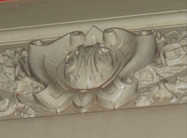
After decades of ships’ gardens and intermittent official use, the mid-1850s turned the place into a serious Royal Navy depot on the Australia Station. In 1913, when the first Royal Australian Navy fleet unit arrived, Admiralty control passed to the Commonwealth. Two world wars thickened the yards into Australias principal fleet base and ship-refitting centre. The Captain Cook Graving Dock, built in the Second World War, joined the former island permanently to the Potts Point mainland — the land bridge you still see when a ferry rounds Garden Island ferry wharf.

Today the precinct is Fleet Base East / HMAS Kuttabul: a working naval establishment with nationally significant heritage fabric, not a picnic island. Public access is restricted; heritage interpretation runs through Navy and related historical societies rather than a casual landing.

Clark Island - Sydney Harbour - Port Jackson - New South Wales

 Clark Island - Sydney Harbour - Port Jackson - New South Wales 

Clark Island is the tiny bush knuckle off Darling Point — less than a hectare, close enough to Double Bay that you feel you could almost swim the gap on a calm day. Early colonial sources record Aboriginal names including Billong-olola / Be-lang-le-wool; modern visitor material also uses Billong-Olo-Lah. It sits on Gadigal Country and was used for hunting and gathering shellfish along the eastern harbour foreshores.

In 1789 First Fleet officer Lieutenant Ralph Clark tried growing vegetables here. In a hungry colony, theft of the crop became a running joke — and a headache — but the name “Clark Island stuck. Later in the nineteenth and early twentieth centuries, like neighbouring Shark Island, it was pulled into public recreation planning: trusts and harbour authorities laid paths and picnic amenity without sanding off the rocky bush character.

Today NPWS runs it as a day-use picnic and event site with a ridiculous view west to the Opera House and Harbour Bridge. There’s no public ferry timetable. You arrive by water taxi, private boat or cultural tour — Tribal Warrior Aboriginal cultural cruises are among the groups that land here. Landing fees and group caps apply; sunrise to sunset is the usual window. Pair it with Shark and Goat (Me-mel) if you’re doing the harbour islands as a set.

A day’s picnic on Clark Island, 1870 — Montagu Scott; State Library of NSW (ML 3).

Shark Island - Sydney Harbour - Port Jackson - New South Wales

 Shark Island - Sydney Harbour - Port Jackson - New South Wales 

Shark Island is the long, low green strip you notice when the ferry swings into Rose Bay — about a kilometre from the bay’s mouth, and small enough that a picnic rug can feel like half the island. NPWS spells the Aboriginal name Boowambillee (older records also use Boambilly). It sits on Gadigal Country as part of the harbour’s fishing and foreshore cultural landscape; keep that general unless youre citing Traditional Owners directly.

The English name is usually tied to the island’s shark-like outline. Yarns about sharks drawn to slaughtering waste still circulate — colourful, but treat them as popular lore, not gospel. Colonial and Federation governments bounced the place between quarantine and public recreation until public pressure helped lock it in as a reserve around 1900. Under the Clark Island Trust and later the Sydney Harbour Trust, Edwardian picnic kit arrived: paths, seats, shelters, and those sandstone foreshore grottos that still look like someone planned a holiday for the tide.

Shark Island joined Sydney Harbour National Park in 1975. It’s still one of the best 360-degree lunch spots on the harbour, and a favourite perch for watching the Sydney to Hobart fleet leave (the 1945 first race is linked with a start off this stretch of water). No scheduled ferry — private boat, water taxi or selected cruises, and a landing fee applies, same regime as Clark and Rodd.

Goat Island - Sydney Harbour - Port Jackson - New South Wales

 Goat Island (Me-mel) - Sydney Harbour - Port Jackson - New South Wales 

Most harbour ferries slide past Me-mel — Goat Island — without stopping. That’s half the point of the place. It sits almost in the middle of Port Jackson, a sandstone knuckle of magazines, barracks, wharves and quiet bush that never became a picnic lawn like Shark or Clark.

Aboriginal people have known it as Me-mel (also written Milmil and similar forms in early records). Colonial writers linked it with the family of Woollawarre Bennelong; today’s NPWS material keeps Me-mel front and centre. From the 1830s the colonial government took over in earnest: water police, convict labour along the shoreline, then magazines and workshops that kept the island a working harbour machine well into the twentieth century. The State Heritage Register listing covers that whole layered mess — Aboriginal, historic and natural — not just a pretty outline on the water.

What’s left is denser than most visitors expect: buildings and structures from the 1830s through to the 1960s, including a Harbour Master’s residence from 1902. NPWS manages the island inside Sydney Harbour National Park while a government-backed process works toward Aboriginal ownership and governance of Me-mel. Remediation and conservation are underway; public access has always been tighter here than on the picnic islands. Check NPWS before you assume you can land.

Pinch Gut Island - Fort Denison - Sydney Harbour - Port Jackson - New South Wales

 Pinch Gut Island - Fort Denison - Sydney Harbour - Port Jackson - New South Wales 

That stubby Martello tower off the Botanic Garden isn’t a postcard prop — it’s Fort Denison, still better known to many Sydneysiders as Pinchgut. Colonial sources record Aboriginal names Mat-te-wan-ye / Muttewai and related spellings; NPWS today also uses Muddawahnyuh. Governor Phillip called the rock Rock Island soon after 1788, but “Pinchgut” won: usually tied to convicts left out here on bread and water, and sometimes to the harbour’s narrow pinch itself.

American warships sailed into the harbour unchallenged in 1839, which concentrated minds. Levelling for a fort began in 1841, then stalled. Crimean War jitters about a Russian attack restarted the work in the mid-1850s. Colonial engineer George Barney oversaw the battery and Australia’s only Martello tower, finished in 1857 with stone from Neutral Bay and named for Governor Sir William Denison. It never fired in anger. The design was already half out of date when the paint was still wet.

From the late nineteenth century the island earned its keep as a light and tide station. A time gun — moved from Dawes Point in 1906 — fired daily at 1 pm so ships could set chronometers; tide measurement has run from here for well over a century. In World War II a shell from USS Chicago, firing during the Japanese midget-submarine attack, damaged the tower. Since 1995 the fort has sat in Sydney Harbour National Park. Check NPWS alerts before you plan lunch on the bastion — conservation closures are not rare.

Fort Denison (Pinchgut) from the water, c.1885 Martello tower and battery already a harbour landmark.

Monday, March 15, 2021

Foundation Of Australia - Loftus Street, Eastern Side - Near Circular Quay

 Foundation Of Australia

Loftus Street, Eastern Side, Near Circular Quay


On The 18th August 1786, Lord Sydney Wrote To The Lords Of The Treasury, Saying That It Was The Kings Pleasure That Ships Be Provided For The Carriage Of 750 Convicts To Botany Bay, Together With Provisions & Necessaries Useful On Arrival. 


A Fleet Of 2 War Ships, 6 Transports, & 3 Supply Vessels, Commanded By Captain Arthur Phillip R.N. , Sailed From Portsmouth On The 12th May 1787 For The New Colony Of New South Wales.


Most Of The Fleet Dropped Anchor At Botany Bay On The 20th January 1788, After A Voyage Of 8 Months, In Which They’d Sailed 15,063 Miles. 


On The 22nd January 1788 Captain Arthur Phillip Headed A Boat Party To A Harbour 9 Miles North Of Botany Bay, Which Captain Cook Had Sighted & Named Port Jackson In May 1770 As He Mapped The East Coast Of Australia (New Holland) With Sir Joseph Banks On The HMAS Endeavour, After The Planetary Conjunction Of Venus In Tahiti Upon King George III’s Instructions. 


Captain Arthur Phillip Noted In The Official Journal That 

“He Had The Satisfaction To Find One Of The Finest Harbours In The World, In Which A Thousand Sail Of The Line Might Ride In Perfect Security.”

“The Fleet Up Anchored Fro

The Fleet Up Anchored From Botany Bay And After A Few Hours Were Safely Anchored And Moored In Sydney Cove. Arthur Phillip Wrote - “


Fwwgeg


Sydney Town Hall at Night – George Street – Sydney – New South Wales


Sydney Town Hall is a 19th-century civic building on George Street, constructed in stages from 1869 to 1889 in the Second Empire style. Its Centennial Hall houses the Grand Organ, one of the world’s largest pipe organs, installed in 1890.


/>


Sydney Town Hall At Night - George Street - Central Sydney - New South Wales 


Mary MacKillop Memorial Chapel – Mount Street – North Sydney – New South Wales

Mount Street, North Sydney, just off the Pacific Highway bustle, drops you into a quieter Josephite precinct. The Mary MacKillop Memorial Chapel at 7–11 Mount Street sits inside Mary MacKillop Place, the Sisters of Saint Joseph of the Sacred Heart campus. Mother Baptista Molloy had the Gothic Revival chapel built in 1913 as a memorial to Mary MacKillop — St Mary of the Cross, co-founder of the Josephites and later Australia’s first saint. Land was given in memory of the Daly family. Archbishop Michael Kelly dedicated the chapel on 18 January 1914.

Only days later, on 28 January 1914, Mary MacKillop’s remains were brought from Gore Hill Cemetery and reinterred in a vault before Our Lady’s altar (the vault associated with her friend Johanna Barr-Smith). On 20 December 1993 the remains were moved again into the former vestry so pilgrims could reach a more accessible shrine, ahead of beatification in 1995 and canonisation in 2010. The chapel remains a working place of prayer and the focus of Josephite memory on Mount Street.

Photographs here show the chapel’s stone exterior, pointed arches and tower profile, and aspects of the Mount Street setting.


Mary MacKillop Memorial Chapel - Mount Street  North Sydney