Search This Blog

Showing posts with label Laneways. Show all posts

Tuesday, March 3, 2020

Rowe Street – Laneways – Sydney – New South Wales


Rowe Street - Laneways - Sydney - New South Wales 

No Street In Sydney Has Had More Words Written About It Than Rowe Street. By The Early 20th Century Its Fine Run Of Terrace Houses Was Being Converted Into Small Shops & Galleries, & Rowe Street Was The Closest Thing Sydney Had To European Chic. 


Upstairs Rooms Were Used As Aritsts Studios, & The Commercial Notanda Gallery Was A Gathering Place For The Artistic Community. In Adjoining Shops You Could Borrow A Book Or Buy An Elegant Hat. 


Many People Remember Window Shopping For The Latest In Interior Design And Parisian Frocks, Buying Some Music At Rowe Street Records Or Enjoying  A Bohemian Espresso At Horton's Gallery. 


The Street Remains, But The Buildings Were Demolished To Make Way For The Construction Of The MLC Centre In The 1970's. Many People Still Mourn Its Passing, & It Continues To Be Cited As A Cautionary Tale Against Overdevelopment & Wholesale Destruction Of The Fine Grain Fabric Of The City. 


Penfold Place & Hosking Place - Laneways - Sydney - New South Wales


Penfold Place & Hosking Place - Laneways - Sydney - NSW 


W C Penfold & Co Is One Of Sydney's Oldest Firms. In 1866 Penfold Bought Out A Printing Business That Had Been On This Pitt Street Site Since 1830, & In 1912 The Firm Bought The Eight Storey Hosking House In Hosking Lane Behind, For An Extended Printworks. 


These Private Laneways Have Served The Firm, & Acted As A Short Cut For Locals For All This Time. 

John Hosking Was Sydney's First Elected Lord Mayor. He Had To Step Down From This Position When He Was Declared Bankrupt In The 1840's Depression. If Only He Could See His Piece Of Real Estate Now. 

Hosking’s Mansion Was Built On the Corner Of Pitt Street And Martin Place On The North Eastern
corner. 

It Was Destroyed By Fire In 1890

The Mansion Became The Site For The Metropolitan Hotel. 


Palings Lane & Ash Street - Laneways - Sydney - New South Wales


Palings Lane & Ash Street - Laneways - Sydney - NSW


The Elegant Complex Of Up Market Restaurants, Pools, Bars And Spas On George Street Is Entered Through Narrow Palings Lane, Which Despite Its Very Contemporary Feeling, Has Been on Or Close To Here For A Long Time. It Was Named Because It Led Through To The Large 1880's Palings Building In Ash Street. W H Paling Was A Musical Entreprenuer Who Imported & Eventually Manufactured Pianos And Sheet Music. Upper Floor Rooms Were Rented Out To Teachers Of Music And Dance, & As Artist's Studios. Ash Street Also Housed The Headquarters Of The Liberal Party Of Australia For Many Years


York Lane – Laneways – Sydney – New South Wales


York Lane - Laneways - Sydney - NSW

This Is Sydney's Longest Laneway. Just Before Barrack Street There Are Some Remnants Of Old Warehouses On The Right, And On The Left Some Residential Apartments. Residents Here Were Some Of The Early Adopters Of The Current Trend Towards Inner City Living That Began In The 1980's.


Wynyard Lane - Laneways - Sydney - New South Wales


Wynyard Lane - Laneways - Sydney - NSW

A Laneway Of Loading Docks & Car Parks, The Back End Of City Businesses. But Note The Hotel Entrance In The 1919 Photo Of This Lane. The Area Was Taken Up With Military Barracks Until the 1840's, & When The Barracks Were Closed In the 1840's, The Military Commander, Edward Buckley Wynyard, Ensured That His Name Was Applied Generously To The Places In This Precinct


Curtin Place - Laneways - Little George Street - Sydney - New South Wales


Curtin Place - Little George Street - Laneways - Sydney - NSW


This Lane, Formerly Little George Street, Forms The Southern Boundary Of The Australia Square Site. John Curtin Was The Australian Prime Minister, 1941 - 1945. Between This & Bond Street, Underneath the Skyscraper, Was Once The Romantically Named Robin Hood Place. 

Two Other Little Lanes, Hamilton Street And Little Hunter Street Run Off Curtin Place. 


Bond Street – Laneways – Sydney – New South Wales


Bond Street - Laneways - Sydney - NSW

Bond Street Remains On The Grid, But Most Of It's Buildings Were Swept Away For The Construction of Australia Square, Opened In 1967. In The Early Decades Of The 20th Century, Bond Street Was A Honeycomb Of Small Shops And Businesses, Inccluding Printers And Publishers. The Influential Magazine Art Australia Was Published From Here, & Bond Street Studios Attracted Tenants Such As Artist Ure Smith And Photographer Max Dupain


Tank Stream Way - Laneways - Sydney - New South Wales


Tank Stream Way - Laneways - Sydney - NSW


Tank Stream Way Was Once Part Of Hamilton Street Which ran From Bridge And Hunter Streets, Named After Hamilton's Biscuit Factory. Most Of It Disappeared Underneath The Australia Square Development, Leaving Two Remnant Laneways, And This Section Was Renamed In 1981. In Bridge Lane, Once The Site Of The Towns first Lumber Yards, Look For The Old Warehouse Doorway, Now The Entrance To The Establishment Hotel. As Late As The 1860's  There Was Still Vacant Land Sliced Between The Cottages In This Area, But By The End Of The 19th Century It Had Become A Favoured Location for Warehouses, Including Several Tea Merchants Stores. 


Abercrombie Lane - Laneways - Sydney - New South Wales


Abercrombie Lane - Laneways - Sydney - NSW


On The Corner Of Abercrombie Lane Is The George Patterson Building, Refurbished As An Upmarket Bar After A Fire That Gutted The Building In 1996. This Building Retains Many Original Features, Including Some Atmospheric Fire Damaged Walls. Walking Down Abercrombie Lane It Is Easy To Imagine That You Are Heading For The Tank Stream. 


"The Spot Chosen For The Settlement Was At The Head Of A Cove, Near The Run Of Fresh Water Which Stole Silently Along Through A Very Nice Thick Wood, The Stillness Of Which Had Then, For The First Time Since Creation, Been Interupted.."

- David Collins - Account Of An English Colony Of New South Wales 1802


When The Water Supply Became Inadequate, Convucts Were Set To Work Digging Holding Tanks Into The Watercourse, And So It Became Known As The Tank Stream. Today The Stream Runs Silently Through A City Drain Below The Pavements. 


Dalley Street - Queen's Place - Charlotte Place - Laneways - Sydney - New South Wales


Dalley Street - Laneways - Sydney - NSW


What's In A Name? Dalley Street, Named After Politician Victor Dalley, Was Once Called Queen's Place. And It's Continuation Across George Street Was Called Charlotte Place, (Now Grosvenor Street). Queen Charlotte Was George III Queen. Queen's Court (Dalley Street) Was Part Of A Warren Of Tiny Lanes & Courtyards That Grew Up Alongside The Banks Of The Tank Stream between The "Official" George & Pitt Streets. 


Underwood Street - Laneways - Sydney - New South Wales


Underwood Street - Laneways - Sydney - NSW


Here Is Another Reminder Of How Remote The Original Waterfront Has Become, As This Is The Place Where James Underwood Built Sydney's First Commercial Shipyard In 1798. The Red Brick Building At The Bend In The Lane Is Unusual, Employing An Architectural Style That Was More Commonly Used In Domestic Apartment Buildings in The 1930's & 1940's 


Bulletin Place - Laneways - Sydney - New South Wales


Bulletin Place - Laneways - Sydney - NSW


The Basement Has Long Been A Favourite Jazz Venue In The City. Beyond This, Warehouses & Stores From The Mid 19th Century Preserve A Little Enclave Of Olde Sydney. The Bulletin Newspaper Was Published Here From 1880, & Writers Such As Henry Lawson & A B Paterson Would Have Frequented This Little Street. 

This Lane Possibly inspired The Lines Of Patterson's Famous Poem 
"Clancy Of The Overflow" 
About Dingy Offices And Folk With 
"Stunted Forms & Weedy, For Townsfolk Have No Time To Grow, They Have No Time To Waste"


Reiby Place - Macquarie Place - Sydney - New South Wales


Reiby Place - Near Macquarie Place - Sydney - NSW 


Today Reiby Place Is Lined With Slick Glass & Concrete, But It's Name Commemorates One Of The City's Earliest Entrepeneurs. 

Before This Area Was Drained, Thomas & Mary Reiby Had A House On the Waterfront Macquarie Place. Mary Reiby, Convicted For Horse Stealing, Became A Wealthy & Respected Widow, & In 1817 Her House Became The First Premises Of Australia's First Bank, The Bank Of New South Wales.

Mary Reiby's Face Is On The $20 Note.


Mary Reiby 1777 to 1855 was a convict who became a highly successful business woman was interested in hotels, trading, shipping, farming in city buildings.

She briefly owns the land around Argyle stores in 1828. Mary Reiby was a governor of the free Grammar School and a founding member of the bank of New South Wales, as well as an active in church and charity work


Loftus Lane - Circular Quay - Sydney - New South Wales


Loftus Lane - Circular Quay - Sydney - NSW 


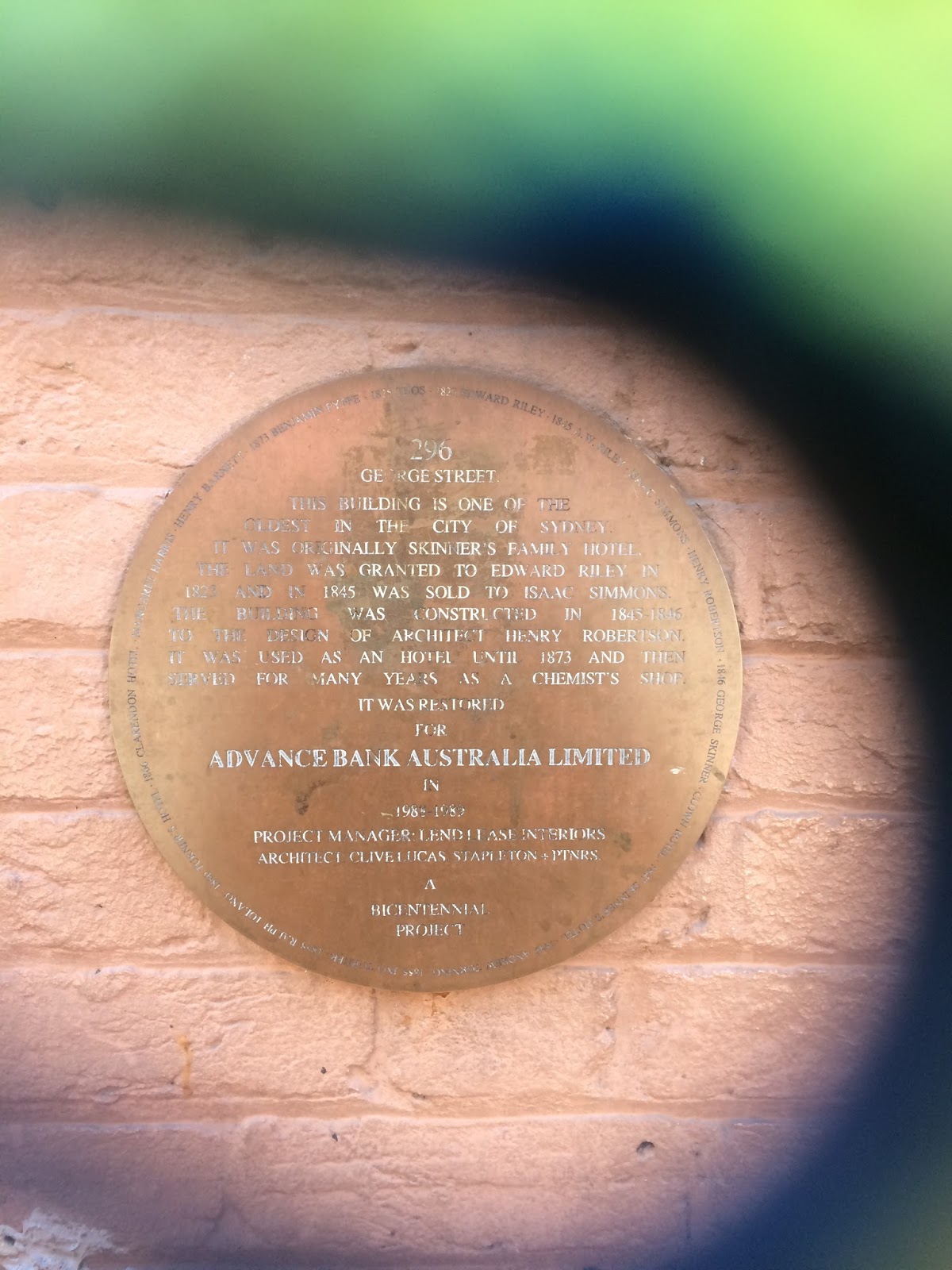
For Most Of Its Life This Laneway Has Served As The Entrance To The Buildings On Loftus Street, Housing Custom Agents, Shipping Brokers & Wool Buyers. The Old Three Storey Sandstone Building On The Right, Which Forms The Rear Of The Gallipoli Club, Was Built In 1876. This & Hinchcliffs Are The Only Remaining Woolstores In The Circular Quay Precinct. 


Customs House Lane - Circular Quay - Sydney - New South Wales

If you duck off Circular Quay into the tight grid between Alfred, Loftus and Young Streets, you’re in the old customs-and-wool pocket of the working port. Customs House Lane sits hard against Sydney’s Customs House — the bureaucratic heart of the quay when wool and general cargo still came alongside. Colonial Architect Mortimer Lewis designed the original Greek Revival building; construction ran 1843–45 on reclaimed foreshore. Overcrowding and damp pushed James Barnet to enlarge and rebuild in the 1880s (wings, another floor, the portico), with later twentieth-century alterations. After Federation the Commonwealth ran customs from here until operations wound down around 1988–90. Today it’s a City of Sydney cultural and library venue — not an active customs office.

On the south-west of the lane precinct, Hinchcliff’s stone wool store (Hinchcliff House, 5–7 Young Street) survives from the staple-export years. Andrew Hinchcliff’s firm built the stone store about 1860 (an earlier iron shed of 1845; a matching late-1880s addition). Mid-century the Society of St Vincent de Paul used it as Ozanam House and, from 1952, part of the Matthew Talbot Hostel for homeless men before the hostel moved on. The façade hoists still read as wool-bale kit if you know what you’re looking at.

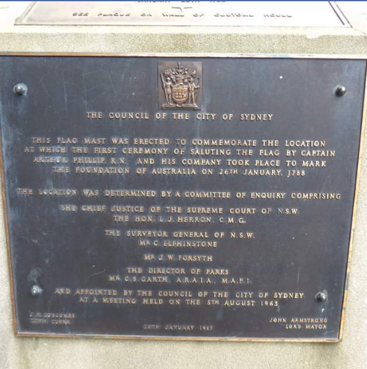
Together the customs house and woolstore tell Circular Quay’s shift from working port to civic waterfront. Soften any claim that a particular Loftus Street flagpole marks the exact 1788 flag-raising site — popular tradition varies; treat flag symbolism as commemorative unless a heritage panel is quoted. Photographs here cover Customs House, Hinchcliff House / the lane, and Circular Quay streetscape.


Customs house was where shipping was cleared and goods passing through the Port of Sydney will text for sale or export.
When the port was busy the house was crowded and noisy, a scene of raised tempers, delays in disputed dealings.

The six story colonnaded building you see today evolve through several phases of expansion between 1845 and 1917.
On Loftus Street alongside the house, union Jack flies permanently on the site where the first British flag was raised.



Friday, May 22, 2015

Macquarie Place - Sydney - New South Wales


Macquarie Place - Bridge Street - Sydney - NSW


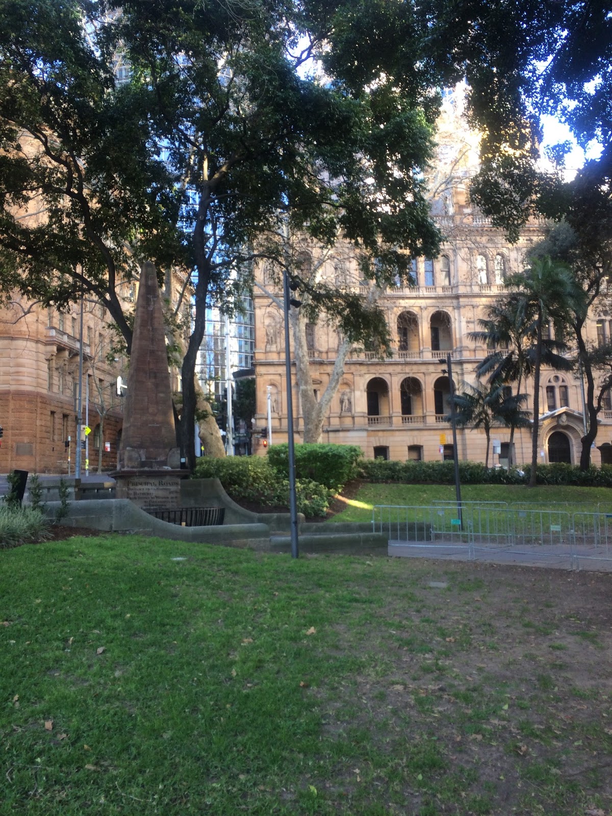
Macquarie Place is that small triangular park at Bridge and Loftus Streets — Tank Stream side of early Sydney Cove — and it still feels like the colony’s front lawn. Governor Lachlan Macquarie regularised it as a civic square; in 1818 Francis Greenway’s sandstone Obelisk of Distances went up as the official zero point for public roads. The inscriptions still give mileages to Parramatta, Windsor, Liverpool, Bathurst, Macquarie Tower at South Head and the north head of Botany Bay. Circular Quay reclamation and street extensions later nibbled the reserve; the old Macquarie Place roadway was folded into the park in the later twentieth century.

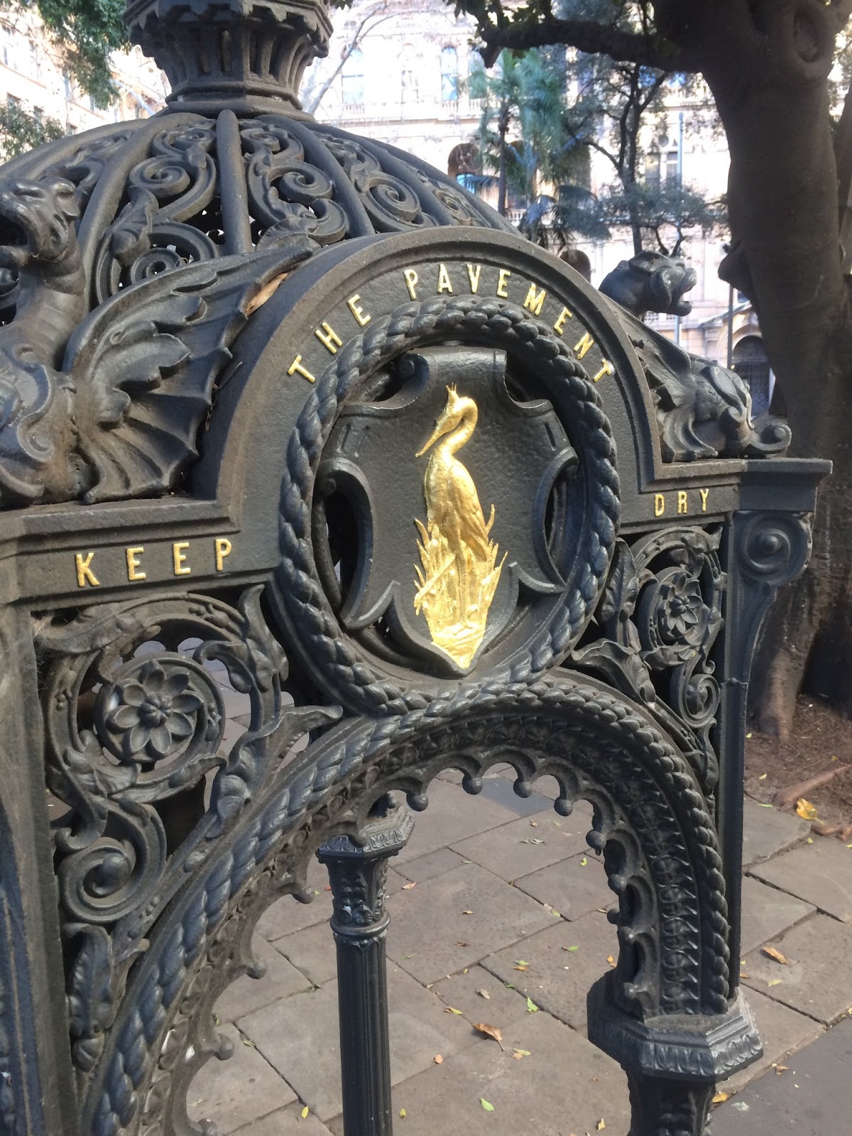
The State Heritage precinct also holds the anchor and a cannon associated with HMS Sirius, flagship of the First Fleet (anchor salvaged from the 1790 Norfolk Island wreck and placed here in the early 1900s; the cannon had earlier signal use at South Head). A bronze of merchant and industrialist Thomas Sutcliffe Mort by Pierce Francis Connelly (1883) stands where Greenway’s Doric public fountain (c.1819–20) once stood — the fountain was demolished to make way for the monument. Other fabric includes 1869 Renny mayoral gate posts, an 1857 cast-iron drinking fountain, traces of a former underground convenience, and plane trees planted in 1954 at the start of the Remembrance Driveway to Canberra.

Images here survey the obelisk, Sirius relics, Mort statue and everyday park use in the CBD.


Originally swampy mangrove land


Originally swampy mangrove land on the banks of the Tank stream, this triangular morsel of land is awash with historic relics.
The obelisk records distance in miles by road to important places in the colony 7 beyond.
The sandstone monument was designed by Francis Greenway, who was sent to the colony for forgery & became Sydney's first Colonial Architect.
Along one side of the park with the Canon & the weather anchor of HMAS serious, flagship of the first fleet which arrived in Sydney in 1788.
The imposing statue of the 19 century industrialist Thomas Sutcliffe mort looks over Bridge Street