
- Sydney Past & Present - - The City Of Sydney - - The Stories Of Its Growth -
__________________________________________________________________________________________________________________________________________________________________________________________________________________________________________
Chapter XIII.
Some Early Suburbs & Islands.
No history of Sydney would be complete without some reference to its early suburbs and the appearance they presented in those days. Gradually the shores of the sequestered bays and inlets were being built upon; and Potts’ Point, Woolloomooloo, Rushcutter, and Elizabeth Bays, the North Shore, Balmain, Pyrmont, and others were becoming favorite residential resorts, of the wealthier citizens who built what were then considered fine mansions —as indeed most of them were—laid out grounds, and made themselves generally very comfortable. On Potts’ Point, at the end of the forties, there may have been half a dozen or so of houses all told. Equally with the old “Fig Tree,” it was then a favorite resort of swimmers who used to go out in parties and race from one point to the other, often paying for their temerity with their lives, by reason either of cramp or sharks. Mundy mentions that, in December, 1849, a man swimming near the Fig Tree, was seized by a very large shark; so close in shore was this, that some of the bathers present beat off the brute with their boathooks. But the poor fellow died from loss of blood in a few minutes.
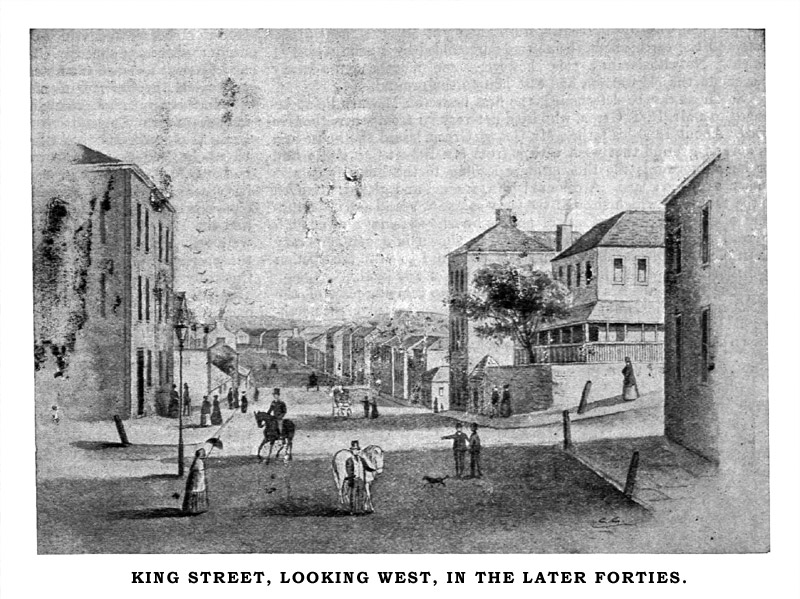
For a great number of years Robinson’s Baths—a large hulk—moored and used as a public bathing place—lay in Woolloomooloo Bay, and was then the only place of the kind in the colony. Higher up towards the head of the bay, somewhere about the site of the present Art Gallery, was a peculiar pile of rocks known as the “Steps,” because somebody had once gone to the trouble of cutting a number of stairs in the cliff. But the “steps” and the surrounding ridges have long ago been quarried and filled up, and now form part of the reclamation upon which is Cowper’s Wharf. High water mark, then, extended to beyond Plunket-street of the present, some thirteen or fourteen hundred feet inland from the edge of the present wharf. There was also an arm of the harbor that ran up in the south-west corner of the bay nearly to Woolloomooloo-street. And although from the shallowness of the bay, there was a great expanse of sand and mud flats at low tide, yet at high tide it was possible to fish from some of the verandahs or windows of a few houses along the shore line.
Much diversity of opinion obtains respecting the name of this old suburb. Colonel Mundy writing forty years ago, says that it is merely a corruption of Wala Mala—the aboriginal term for “the Place of Tombs,” and that it was an old burial place of the blacks. Other authorities give the correct spelling as Wallahmulla, and say that it is derived from the fashion after which the natives tried to pronounce the word “windmill.” Mundy’s theory, or rather that of whoever gave him the information, seems the most feasible. However this may be, Woolloomooloo was originally a grant to Mr. Commissary Palmer, who formed upon it a sort of model farm. The boundaries of the estate reached from the water to the Old South Head road, now Oxford-street, and were defined by ditches and high stone walls. Mr. Palmer himself lived in a house near the junction of Palmer and William streets, which was later on occupied by Archbishop Polding. Afterwards, about a hundred acres of the grant were acquired by a Mr. Riley, and for long afterwards was known as the Riley estate.
Rushcutter’s Bay—so called from the fact that there, in 1788, two men, convicts employed in cutting rushes, were set upon by natives and speared to death—was in especial favor for residing in at this time. It must not be forgotten that the bay, or rather its foreshores, was the spot where was established what might be called the first Australian market garden. To the south, at the head of the bay, there spread a big flat enriched by alluvial washed down from the adjoining high lands and added to by silt from the shores. When the New South Head road was made, this valley above it was drained and formed into a big series of vegetable beds, which supplied the city for many years. Through the centre of the valley ran a creek, spanned by a strong bridge with a single arch just where it was crossed by the Lower South Head road. At a short distance from this Rushcutter’s Bay bridge, on the left-hand side, stood a house of call known as the “White Conduit House,” Early settlers in the colonies were prone to call places in the new land after other and well-known ones at home. And, in this instance, the “White Conduit” perpetrated its English namesake far away in Pentonville, noted for its arbors, fish ponds, and shady walks, also as a resort on Sundays of citizens, their apprentices and wives; where they could get hot loaves and butter, tea and fresh milk. And, in some sort, such were the inducements held out to visitors from the city by its Antipodean prototype at Rushcutter’s Bay. To reach it one took a pleasant stroll across the paddocks adjoining Hyde Park, through Woolloomoolloo Valley, and up to the eastern heights via the present William-street—then a pretty country lane, fringed at intervals with gardens; then past the great stone windmills on Darlinghurst, through some scrubby gullies, and to the White Conduit for a “long sleever” of Cooper’s XXX, or, perhaps, something stronger hailing from Underwood’s distillery not very far distant.
The old house, although a good deal altered, still stands, and is easily recognised by old residents.
As for Darling Point, to which, just past the “Conduit,” the road turned off, it was considered in those days rather too remote for a suburban residence. But, later on, T. S. Mort “took hold” on the point, and showed, in beautiful “Greenoakes,” what could be done by judiciously assisting nature with art. Those who remember “Greenoakes” in its palmiest days will endorse the success of his undertaking, and his taste in landscape gardening of a high order.
In 1849, was laid the foundation of the pretty church of St. Mark’s; the work went on until 1851, when the gold fever broke out in Australia; labour prices rose sky high, and the building was perforce stopped. It was, however, resumed in 1852, with the result of producing one of the prettiest churches in the colony. For a very long time Potts’s Point remained one of the most secluded of all Sydney’s suburbs. Its rocky foreshores, and rude, steep cliffs, clothed with thickets of lantana, and bunches of prickly pear and “pig-face,” formed indeed, an ideal spot for picnics; and it was easily got at by a short cut across the sands of Woolloomooloo Bay, But for many years there were only a few scattered dwellings.
Turning our attention to the North Shore, we find that so long ago as 1824 or 1825 Sir Thomas Brisbane made a grant to Mr. James Milson, sen., of 50 acres of land situated between Careening Cove and Lavender Bay. He might have had more, but as cultivation was the purpose he had in view, and the ground was decidedly unsuitable, he went further afield, and in the neighbourhood of Hornsby selected a large tract of the fertile soil there. Mr. Milson was one of the first residents on North Shore.
Another grant was made by Macquarie to William Blue of some 90 acres, now known as Blue’s Point, extending in an easterly direction towards Milson’s Point. Mr. (better known as “Billy”) Blue, was a native of the West Indies, and one of his daughters married Mr. Lavender, to whom was given by his father-in-law that part of the original grant now known as Lavender Bay. Prior to this it was known as Hulk Bay; and Mr. George Lavender was in charge of the hulks, on board of which the convicts were kept waiting transference to the Swan River settlement in Western Australia. A writer, to whose researches, made with great care and trouble, much of the information respecting North Shore here set forth is due, says he was informed by Mr. J. S. Abraham that the native name of Lavender Bay was Quilby. During the first fifty years of the colony’s existence the thickly growing timber of the North Shore forests was much made use of for building and other purposes. It seems to have been mostly big gum, and was felled and dressed by gangs of convicts. But there were fig trees, too, of great size. One specimen was, until recently, still standing at Milson’s Point, The roots and the earth about them were surrounded by a solid casing of cement. Notwithstanding this, however, some months ago a heavy gale smote the old warrior, and cast him to the ground.
So far as can be determined, the first house on Milson’s Point belonged to a Mr. H. T. Green, who lived not very far from where the tree stood. About 1850 his father, Mr. George Green, leased the house and an acre of ground that went with it from Mr. Robert Campbell; and for long afterwards the thoroughfare leading to the horse ferry was known as Green’s lane. A coloured plan, framed and glazed, attached to the tree, and which showed the ferry company’s land and its boundaries, often excited the curiosity of passers by who were not near enough to read it. The original landing-place, as shown in a contemporary picture, was a low stone wall, and this remained so until the erection of a wharf, upon which, however, was no shelter of any kind.
“The Point” appears to have been a favorite camping-place of the blacks, notably the Cammeray tribe, then the most powerful on the northern side of the harbor. The first hotel opened on the Point was that known as the Figtree, at Blue’s Point road, kept by Mr. Thomas Redgrave. This was in 1841. In 1843, Mr. Burns opened the Union Inn, near the Crow’s Nest, on Lane Cove road, and in 1845 Mr. Whitford started business in the Lily of St. Leonard’s, still to be seen, modernised, on nearly the same site in Alfred-street. In explanation of the rather curious name of this last hostelry, the late Hon. Geo. Thornton told the writer already referred to, that, in the time of Mr. Dind, one of the landlords, the sign was the figure of an aboriginal woman; and that probably the title of the house was merely intended as an early day witticism.
The Milson family is, of course, intimately associated with the history of the point bearing its name. Mr. Milson, sen., was one of the earliest settlers upon it, and his son (Mr. James Milson) was among the first to establish a steam ferry across to the city. Deputy-Commissioners Miller and Walker, after whom two of the principal North Sydney streets are named, were also associated with Mr. Milson in this undertaking.
The first steam ferryboat to ply from the point was named the Princess, and was built at Balmain by Mr. Budevent to run as a punt transit of horses and vehicles. She, however, does not seem to have been a success financially. Some time afterwards Captains Joseph and Thomas Gerrard ran a steamer built by Mr. Chowne, of Pyrmont, and called the Fairy Queen.
In the early fifties a company was formed, which imported a steamer in sections from England. It was put together in Sydney, named the Herald, and ran between Blue’s and Miller’s Points. The Gerrards then changed their route to Milson’s Point. Messrs. J. Milson, jun„ F. Lord, W. Tucker, C. Firth, and others were the founders of a steam ferry company trading between Sydney and the North Shore. They owned three boats—the Alexandra and the Kirribilli for passengers, and the Transit for vehicles. After much keen competition the fares were reduced from a shilling each way to sixpence, and ultimately to threepence. In 1878 this company sold out to the North Shore Ferry Company, and the late Captain Summerbell was appointed manager. The fare was then reduced to twopence, and, then, some years ago to one penny each way.

Thirty odd years ago there was a steam ferry from Circular Quay to Milson’s Point, running boats every quarter of an hour; and at the same periods from Pottinger-street (Macnamara’s Wharf), near Windmill-street, to Blue’s Point all at threepenny fares each way. Total daily traffic, about 150 passengers. Settlement, it will thus be seen, was then scarce enough in our present big suburb of North Sydney. This was due in part to the expense of clearing the heavy timber, also to the fact that holders of land preferred to keep it unimproved in the certain hope of an ever-increasing value. Land in the early days of the Shore was leased for £3 per annum per acre; £50 per acre per annum would be nearer the present average rate in many spots there.
Manifestly, a history of the harbor would be out of place here. But a glance at the early aspect and history of two of its islands, inseparably bound up as they are with the story of our city, will be of interest.
Of Garden Island, where Phillip tried with but a small measure of success to grow vegetables for his infant colony, mention has already been made.
As to quite how many times the island we now know as Fort Denison has changed its name seems uncertain. When Phillip arrived it was a picturesque rock, called by the natives Mal-te-wan-ye. The Govenor altered that to Rock, or Rocky, Island. Then, at the first “criminal court assembled on February 11, 1788 (says one account), a convict found guilty of robbing another of some biscuit, was sentenced to be confined on this island for a week, and to be fed on bread and water alone. The other convicts promptly dubbed the spot “Pinchgut,” a name that may be said to have stuck to it until the present day. Another early historian says, speaking of the harbor islands: “The most noted being one fronting the Cove, bearing the unpoetical name of ‘Pinchgut’ on account of its having been the primitive prison of the colony, and the spot whereon malefactors were in olden times hung in chains!” Again one of the oldest writers, referring to this island, says: “On the 29th of November, 1796, eight men had sentence of death passed upon them, Francis Morgan, for murder, was executed and his body hung in chains on the island of Mal-te-wan-ye. This spectacle shocking to the refined mind, served as an object of ridicule to the convicts and terror to the natives, who, though hitherto particularly partial to that spot, now totaly abandoned it lest the malefactor should descend and seize them in the same way as their superstition prompted them to imagine spirits did.”
Respecting this island Lang writes: “There was a remarkable rock or islet which from time immemorial had occupied a prominent position in the harbor in the approach to the city, and which formed a striking object in the field view from the surrounding heights consisting as it did, of a vast mass of grey, weather-beaten rock rising perpendicularly in a slender column to an elevation of 75ft from the deep water… This natural ornament of the harbor, however, which no art could have equalled—this remarkable work of God, which had stood like a sentinel keeping watch upon the harbor for thousands of years—was at length destroyed by the folly of man; some official Goth or Hun, who must surely have had the organ of destructiveness largely developed, persuaded the local Government of the day to quarry down the rock very nearly to the water’s edge, with a view of being converted into a battery, forsooth, for the protection of the harbor! The work of destruction accordingly commenced, and proceeded apace till this fine object in the field of vision for miles and miles around in every direction was forever destroyed, and the romantic islet at length replaced for ten or twelve years thereafter by the unsightliness of an abandoned quarry. For, as usually happened with Government works under the beautiful colonial system of the past, the idea of having a fort on Pinchgut Island was given up after a large expenditure had been incurred in the work of destruction—perhaps from feelings of compunction on the part of its authors, if not in consequence of some unfavorable opinion respecting the proposed erection from the Ordnance Department in London; and huge piles of rough stones, heaped up in all possible forms of irregularity and confusion, were, for many years thereafter the befitting monument of this precious piece of official vandalism.”
Sir William Denison seems to have, in some sort, made a hobby of the place; and he it was who had the existing “fortification” constructed, an abnormal sort of martello—tower—cum—bastion business. A very nightmare of a fort, even as says “Peter Possum,” “decorated with a tower like a gigantic hat, a monstrously magnified drab ‘mountcastle’, which doth not add greatly to the harbor’s picturesqueness.”
And the crown of bathos was set on the whole affair by the discovery, presently, that, owing probably to the porous nature of the sandstone upon which it was built, it was not possible to fire a gun as a time signal, without shaking the island to its foundations! The most it can do, indeed, seems to be to display a red beacon light o’ nights.
Respecting Cockatoo Island, a writer in the forties says: “This natural hulk is situated about two miles above Sydney, just where Port Jackson narrows into a creek called the Parramatta River, and about a quarter of a mile from either shore. Here is all that remains of that stupendous machinery, which, from first to last, has introduced into and diffused through these colonies not less than 60,000 of Great Britain’s offenders, and by whose agency it may be said this great fifth portion of the globe has been redeemed from the savage and appropriated to the European family.
“The isle is a triangle in form, about 400 yards long by 280 in width. It contains at present about 300 prisoners under conviction for offences committed in the colony, or expirees from Norfolk Island. Many of these are regular incurables, doubly and trebly convicted. The prisoners are employed in quarrying stone, in laying down a clear and spacious wharf around this rugged isle, so that a few sentries can command the entire circumference. They are, moreover, engaged in the useful work of excavating a dry dock—a convenience that does not at present exist in these colonies.
“The establishment is admirably adapted, both by nature and art, to its purpose. Nevertheless, many desperate attempts to escape were made in my time. One wretched man flung himself into the water, loaded with chains, and, being a powerful swimmer, had got nearly a hundred yards from the pier before the sentry perceived him. Disregarding the soldier’s shouts and threats, the man swam steadily onwards, upon which the sentry fired and the wretch instantly sank; nor was his body ever found. Sharks in search of offal from the slaughter-houses haunt this part of the harbor, and act as an efficient ‘cordon.’
“The great curiosity of Cockatoo Island is the siloes—excavations in the solid rock, shaped like a huge bottle, 15 or 20 feet deep by 10 feet wide, with a narrow neck, closed by a stone capsule luted with plaster. About a dozen and a half of these siloes, filled in time of plenty with grain, were intended as a reserve of food for seasons of famine, which have more than once befallen the colony. It was a monopoly for the public benefit; but the plan was discountenanced and disallowed by the Home authorities—I suppose because it might interfere with the agricultural interests.”
These excavations were afterwards used to conserve a supply of fresh water for the island. Some of them are still in existence, and their sites may be readily traced.
Such was Cockatoo Island in the later forties, when Fitzroy ruled the land, and gave his name to the dock mentioned above, and since eclipsed by its big neighbor, the Sutherland. There is still a penal establishment there, known to us as Biloela. But the prisoners are only weak phantoms of their fierce and unruly prototypes—“drunk and disorderlies,” “no visible means,” etc., with a sprinkling of short time thieves, larrikins, and such-like gentry; many of them old, decrepit folk of both sexes, who hail the gaol more as a refuge than a place of punishment; an asylum where regular meals, enforced cleanliness, and a fair amount of work enable them to regain in part their shattered health before once more appearing in society.
There are, perhaps, other islands in our harbor whose stories are worth writing. But other chroniclers will doubtless be found to discourse upon Goat, Spectacle, Shark, and the rest of them that may have any tradition attached to their names, ancient or modern. The three strictly historical islands, however—Garden, Pinchgut, and Cockatoo—seem to be the only ones that by their early connection with the history of our city call for special mention in this work
No comments:
Post a Comment