These pages come from the sketchbook of an artist whose name I don't know. Whoever they were, they spent the years 1909 to 1913 wandering the harbour foreshores and the eastern suburbs with a pencil and a box of watercolours. Most pages carry a place and a date in the artist's own hand – Point Piper, Double Bay, Bellevue Hill, Billyard Avenue at Elizabeth Bay, Vaucluse, Watsons Bay, The Gap and South Head, and Coogee. A few stray across the water to Dawes Point, Balls Head and the entrance to Mosman's Bay, and there's one memory sketch of Jervis Bay.
What I love about them are the little notes to self. The artist reminds themselves to “put the bluey distance” into a view from the rocks at South Head. Another page records a tree that was cut down within three hours by someone with a long ladder, who carted the branches away. These aren't colonial drawings – they're from just after Federation – but they show a Sydney that's gone now: road-making between Bellevue Hill and Rose Bay, sailing boats off Fort Denison, and open headlands where there are houses today.
I've kept the artist's own captions and dates, with a few spellings tidied up. Where a page had no caption I've left it blank.
Related posts on this blog: Tiranna – 17 Billyard Avenue – Elizabeth Bay · Elizabeth Bay House
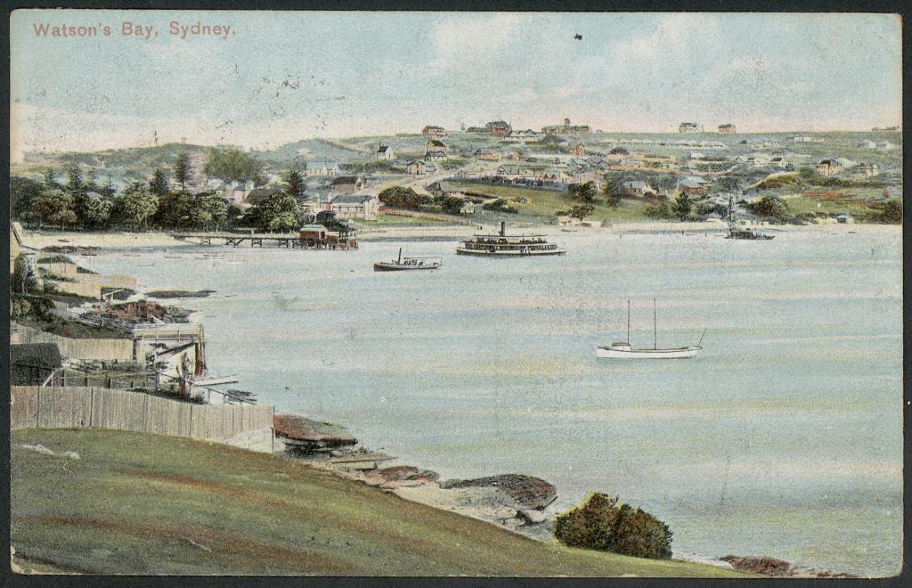
Watsons Bay, Sydney, 1905 – postcard (Powerhouse Museum collection)Image: Powerhouse Museum collection – via Wikimedia Commons (Public domain). Source
Double Bay from Darling Point, c. 1900 – Tyrrell Photographic Collection (Powerhouse Museum)Image: Powerhouse Museum collection – via Wikimedia Commons (no known copyright restrictions). Source
Drawings Of The Sydney Eastern Suburbs & Harbour – An Unknown Artist's Sketchbook – 1909–1913
________________________________________
Sitting Near Elizabeth Bay
________________________________________
Rozelle Bay
________________________________________
On Road - Near Bellevue Hill 7th February 1909
________________________________________
This is The Next Headland Next To The Northern Head Of Coogee Bay
________________________________________
Double Bay - 14th February 1909
________________________________________
Fort Denison From Point Piper 8th January 1909
________________________________________
________________________________________
Looking Towards Clark Island From Vaucluse
________________________________________
View From Double Bay Looking North East
________________________________________
Looking Out To The Ocean Somewhere From South Head
________________________________________
From Near Elizabeth Bay - View Looking North At 5.30pm 16th October 1913
________________________________________
Rushcutters Bay
________________________________________
1 - Sunset From 97 Victoria Street 25th August 1912 2 - From Coogee North Side Looking To South Coogee 30th October 1913
________________________________________
1 - Memory Sketch - Jervis Bay 2 - Bellevue Hill Looking North 12th April 1912
________________________________________
Looking Towards Lighthouse At South Head 14th March 1912
________________________________________
16th February 1912
________________________________________
21st November 1911
________________________________________
Near Vaucluse 19th September 1911
________________________________________
From Near South Head Cemetery 30th January 1911
________________________________________
1. From Rocks Near South Head This Is A Lot Further Off Than Sketch. See Detail & Put The Bluey Distance & Less More Flat In Surfaces Of Rocks in Distance 9th December 1910 2 - From Rocks Near South Head 9th December 1910
________________________________________
Tree Cut Within 3 Hours Who Had Long Ladder & Took Away The Cut Branches 9th August 1911
________________________________________
Peep Between Trees - Billyard Avenue - Elizabeth Bay
________________________________________
At South Head
________________________________________
The Gap - Looking Down South Head Road In Distance 9th October 1910
________________________________________
This Is Billyard Avenue Looking East 2nd November 1912 - 4pm
________________________________________
The Heads At 4pm
________________________________________
1 - Sketch of The Road In Bellevue Hill to South Head Road - Looking North At 4pm 12th September 1910
________________________________________
Sea Calm - Freshwater Point Saturday 20th July 1910
________________________________________
1 - Fort Denison 2 - Eastern Bay Somewhere Near South Head
________________________________________
1 - Between Bellevue Hill & Rose Bay - Road Making 6th April 1910 2 - Fort Denison From Potts Point View From Watson's Bay 5th April 1910
________________________________________
________________________________________
Mr B's Garden ?? 2nd April 1910
________________________________________
Looks Like The Swimming Pool at Either Bronte Or Bondi Beach
________________________________________
From Dawes Point
________________________________________
________________________________________
Point Piper 16th November 1909
________________________________________
Rose Bay 11th November 1909
________________________________________
1 - Looking Towards Parramatta River From Dawes Point. Ship Is Passing Near Goat Island 9th November 1909
________________________________________
1. Balls Head Looking West 4.30pm From Near Blues Point 27th October 1909 2 - 16th February 1909
________________________________________
Near Point Piper 20th October 1909
________________________________________
Near Point Piper 5th October 1909
________________________________________
Point Piper 23rd September 1909
________________________________________
12th August 1909
________________________________________
View Of Fort Denison From Potts Point
________________________________________
1 - Bellevue Hill 17th July 1909 2 - Near Watsons Bay Towards South Head 22nd July 1909
________________________________________
Entrance To Mosman's Bay 10th July 1909
________________________________________
1 - 10th July 1909 2 - 7th July 1909
________________________________________
________________________________________
________________________________________
________________________________________
________________________________________
________________________________________
________________________________________

.jpg)
.jpg)


.jpg)


