Search This Blog

Wednesday, December 7, 2016

Richmond Looking West – Tasmania

This view looks west across Richmond, Tasmania — Coal River country, one of Van Diemen’s Land’s early inland townships, not the Hawkesbury namesake outside Sydney. From the 1820s the crossing here pulled settlers, soldiers and convict work-gangs into a compact Georgian village that still reads as a film set when you stand on the rise.

The hero of most “looking west” postcards is Richmond Bridge: convict-quarried sandstone arches begun in 1823 and finished in 1825, still carrying traffic, and listed on the National Heritage List as Australia’s oldest surviving large stone arch bridge. The gaol nearby (from 1825) is among the country’s oldest surviving prison compounds. Together they explain why Richmond became a staging post between Hobart and the east-coast / Port Arthur roads.

Keep these six photographs. Caption by bridge, river flats and township roofscape if the frames support it; don’t drag NSW Richmond or Windsor into a Tasmanian paddock.


This view looks west across Richmond, Tasmania, one of the island’s oldest settled townships. Founded in the 1820s on the Coal River, Richmond is known for its surviving Georgian buildings and historic bridge.


Richmond Church and Rectory

If you drive out to the Hawkesbury and come into Richmond along Windsor Street, St Peter’s sits on the rise above Pugh’s Lagoon as if Macquarie had planted it there — which, in a way, he did. This is one of his five Macquarie Towns. On the Hawkesbury tours of 1810–11 he chose an elevated bank for church, schoolhouse and burial ground; on 10 January 1811 the site was marked out with strong posts. An early schoolhouse-chapel served the town until a purpose-built church was needed.

The present Colonial Georgian church was designed by Francis Clarke and built by James Atkinson between the later 1830s and 1841. Bishop William Grant Broughton consecrated it on 15 July 1841. The picturesque rectory, also by Clarke, was completed in 1847. Edmund Blacket later altered the church — porch 1850, chancel mid-1850s — and remodelled the rectory in 1863. The group — church, rectory, school hall, cemetery and stables — sits in a park-like setting overlooking the lowlands and is listed on the NSW State Heritage Register.

Photographs here show the Richmond church and rectory group in the Hawkesbury landscape. This is St Peter’s, Richmond (Hawkesbury), NSW — not St Luke’s, Richmond, Tasmania.


Tuesday, December 6, 2016

King Street, Sydney – Looking West

King Street cuts east–west through the CBD — Domain / Macquarie Street at one end, the land falling toward Darling Harbour / Cockle Bay at the other — named for Philip Gidley King, First Fleet officer and Governor of New South Wales (1800–1806). Nineteenth-century “looking west” views catch shopfronts, hotels and horse traffic on the descending ridge — the commercial grain between George, Pitt, Castlereagh and Elizabeth.

The street stayed a retail and theatre-adjacent corridor well into the twentieth century, rebuilt after fires and boom cycles. Images here belong to that looking-west documentary habit rather than to one surviving landmark façade. Caption by identifiable corners, signage or vehicles where you can read them — and don’t confuse this CBD King Street with Newtown’s King Street.


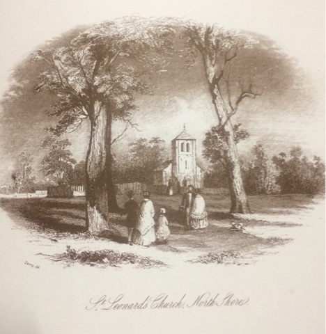
St Thomas’ Anglican Church, North Sydney (historic St Leonards)

The live title says “St Leonard’s Church, North Shore” — but the Anglican parish church of the old township of St Leonards (today’s North Sydney) is St Thomas’, on McLaren / Church Streets. Land was set aside as the north shore settled in the 1820s–40s. The first St Thomas church, generally attributed to Conrad Martens, was begun in the early 1840s, opened in 1846, and tied to Bishop Broughton’s early pastoral work on this side of the harbour. Martens’s carved font is still reported in use.

Population growth demanded a larger building. Edmund Blacket designed a new Gothic Revival church; the foundation stone for the nave and tower stage was laid in 1881, and the completed church was dedicated in 1884 (works continuing under Cyril Blacket after Edmund’s death in 1883). Built of locally quarried stone, St Thomas’ is among the longest Anglican parish churches in New South Wales. The proposed tower was never fully realised as originally intended.

Prefer the correct dedication St Thomas’ in titles and captions; “St Leonards” properly names the historic township/district.


Mm

The Anglican parish church of the old township of St Leonards — today’s North Sydney — is St Thomas’ Church on McLaren / Church Streets, not a separate surviving building named “St Leonard’s Church.” Land was set aside as the north shore settled in the 1820s–40s. The first St Thomas’ church, generally attributed to Conrad Martens, was begun in the early 1840s, opened in 1846, and associated with Bishop Broughton’s early pastoral work on the north side of the harbour. Martens’s carved font is still reported in use.

Population growth required a larger building. Edmund Blacket designed a new Gothic Revival church; the foundation stone for the nave and tower stage was laid in 1881, and the completed church was dedicated in 1884 (works continuing under Cyril Blacket after Edmund’s death in 1883). Built of locally quarried stone, St Thomas’ is among the longest Anglican parish churches in New South Wales. The proposed tower was never fully realised as originally intended.

Photographs here appear to show that North Shore parish church and its nineteenth-century fabric. Prefer the correct dedication St Thomas’ in titles and captions; “St Leonards” properly names the historic township/district.


Courthouse and Scotch Church – Parramatta

The old prints call it “Courthouse and Scotch Church, Parramatta” as if they were a pair you could still walk between. You can’t — one is mostly gone, the other left town. Those colonial views show two neighbouring civic buildings near the corner of Church and George Streets: the second Parramatta Courthouse and the Scots’ (Presbyterian) Church, later known as St Andrew’s.

The courthouse was a Greek Revival sandstone building associated with Colonial Architect Mortimer Lewis and builders James Houison and Nathaniel Payten, put up in the late 1830s (opened for use in the late 1830s–1840) and extended mid-century. It served until a later courthouse generation replaced it; only fragments (notably a sandstone wall and cell block behind the George Street frontage) survive from the Lewis complex. Some of the old courthouse columns were reused in the Boer War Memorial in Parramatta Park.

The Scotch Church — St Andrew’s Presbyterian Church — was a Victorian Gothic landmark on Church Street. Construction began about 1840 (architect James Hume, with local associations to James Houison) and the church was completed in the 1840s. When a larger St Andrew’s opened elsewhere in Parramatta in the 1920s, the old “Auld Kirk” was dismantled and re-erected at McKern Street, Wentworthville, where it was dedicated in 1928. These images therefore record a nineteenth-century streetscape pairing that no longer stands together in central Parramatta.

P


The Parramatta Courthouse and Scotch Church were important civic and religious buildings in the colonial town. The Scotch Church served Parramatta’s Presbyterian community, while the courthouse supported the town’s growing judicial and administrative life. Together, they reflect Parramatta’s development as a major centre in nineteenth-century New South Wales.


Garden Island, Pinchgut, and Clarke's Island, Seen from Rose Bay

From Rose Bay the harbour still reads as a set of rocks in a drowned valley, even though one of them has been stapled to the mainland. Garden Island was the First Fleet’s kitchen garden for HMS Sirius in 1788, which is the whole of the English name. The navy never really left. By the 1850s it was a Royal Navy yard; the RAN took it in 1913; in the 1940s the Captain Cook Graving Dock filled the channel to Potts Point, and the island became a peninsula. What you photograph from Rose Bay is a working dockyard pretending to be a headland.

The little fortified stack closer in is Pinchgut, officially Fort Denison. Governor Phillip’s Rock Island became a convict isolation rock — the “pinchgut” ration story is folklore with a nautical rival, a pinch in the harbour. George Barney had the old pyramid cut down and raised a Martello tower, finished in 1857. John Dunmore Lang called the levelling vandalism against a work of God. He had a point; the silhouette is now all gun and garrison.

Clark Island — the extra e in Clarke’s is the usual slip — sits off Darling Point, named for Lieutenant Ralph Clark of the First Fleet, who ran a convict-tended vegetable garden there. It is a pocket of Sydney Harbour National Park: picnic tables, no ferry, bookings for weddings. Three different fates in one view — dockyard, fort, picnic — which is the harbour in miniature.


Entrance to Sydney Harbour – North Head

Stand on North Head on a clear day and you understand why every colonial chart and postcard obsesses over “the Heads.” This is the northern side of the seaward entrance to Port Jackson — Sydney Harbour — opposite South Head, near Manly. Contemporary park interpretation uses Aboriginal names such as Car-rang-gel (and related Gayemagal spellings); use published park or council forms carefully. From early colonial times the headland was a landmark for shipping and a vantage for signal and lookout posts — historic views “from the Flagstaff” look out across the Heads toward the ocean and the harbour mouth.

In 1832 the colonial government reserved much of North Head for quarantine. The North Head Quarantine Station operated from 1832 until 1984, receiving ships and passengers whose health threatened the colony and later the nation. It is among Australia’s most intact quarantine complexes and is listed on both the National Heritage List and the NSW State Heritage Register (as part of the wider North Head / Sydney Harbour National Park landscape). After closure the station passed to NSW National Parks and Wildlife Service; the leased tourism precinct is widely known as Q Station, still inside the national park and under heritage controls.

North Head also carries layers of Aboriginal Country, twentieth-century defence works, and remnant bushland of high conservation value. Treat this post as an entrance-to-the-harbour essay: keep the Flagstaff viewpoint if your images are historic prints, and let quarantine and national-park history give the place depth without inventing ship names or outbreak tallies.


Monday, November 14, 2016

Admiralty House - Kirabilli - Governor General's Residence


I Guess That Everyone   Knows That Adiralty House Is The Residence Of TheGovernor  General When In Sydney.


Originally The Land Was Acquired By The New South Wales Government In 1885 As A Residence For The British Officers In Command Of The Australian Naval Station. 
At That Time London Took Responsibility For Defence On The Southern Continent. A Dozen Admirals Had Resided There  Up Until 1913 When The Royal Australian Navy Was Established.


Back in 1806 When Kiribilli Was Wild And Uninhaited, Robert Campbell Bought The Property For a Few Pounds. 


It Surprises People Today That Kirribilli Point Was Referred To As "Russian Point". This Began in 1814 When The Russian Shhip SUVOROV Called In To Port Jackson. 


Colonnaded stone building, which which explains the garden dominate the Kirribilli, and has since 1916 been a resident of Australia’s governor general.

The house was bought in 1885 by the state of New South Wales as a residence for the naval commander in chief. Earlier the house of been described as having a white Veranda, spacious entrance hall, drawing and dining rooms, 10 bedrooms, and the usual rooms in the main part of the house for large courtyard, seventh rooms, kitchen stables etc with an abundant water supply which never fails in the driest weather.

To make this residence fit the British Admiral grand proportions. Did therefore came like a thunderclap to the state of Florida keys from the second last at McHughes it, for George King Cole, struck his black bear and handed the residents over to the Commonwealth.


Thursday, November 3, 2016

Francis Greenway’s Public Fountain – Bent & Spring Street

Under Governor Lachlan Macquarie, Francis Greenway designed a sandstone Doric public fountain for Macquarie Place that small civic triangle that marked the administrative heart of early Sydney. Built about 1819–20 by stonemason Edward Cureton (with taste often credited also to Elizabeth Macquarie), it stood on the western side of the reserve so townspeople could draw water without entering the Governor’s Domain. The Bent and Spring Streets corner sits in the same colonial civic precinct; period descriptions put the fountain in Macquarie Place, not as a free-standing ornament mid-intersection.

It was one of Greenway’s civic works from the Macquarie years — a period Commissioner John Thomas Bigge famously called extravagant. By the 1880s the fountain was dilapidated; it was demolished around 1883–87 and replaced by the statue of merchant and pastoralist Thomas Sutcliffe Mort that still occupies the western corner. No Greenway fountain fabric survives above ground.

Photographs here relate to the Macquarie Place site and the memory of Greenway’s lost Doric fountain.


Friday, September 30, 2016

Sydney Garden Palace – Part 5

Part 5 of the Garden Palace scrapbook — same vanished giant, this time through the music. Barnet’s exhibition hall in the Inner Domain opened for the Sydney International Exhibition (17 September 1879 – 20 April 1880). Milanese composer Paolo Giorza, picked as musical director by Sir Patrick Jennings, wrote the opening cantata to words by Henry Kendall and kept the nave busy with daily concerts, oratorios, bands and chamber music while more than a million visitors walked the courts.

This instalment’s plates lean toward programmes and performance memory — including sheets that name Beethoven and Grieg — rather than another full run of exterior dome views. Read the print before you claim a premiere night. One Exhibition-era Bechstein grand that took first prize in the musical-instruments class survived the building; the Palace itself did not. Fire in the early hours of 22 September 1882 took the timber palace in about forty minutes.

For the longer chronology and the big pictorial set see Sydney Garden Palace in Pictures; Part 7 carries another tray of views. Keep these five images; caption by programme, nave or instrument, not by inventing a conductor’s diary.

Sydney’s Garden Palace was built in the Domain for the 1879 Sydney International Exhibition, which showcased industry, arts and science. The grand exhibition hall hosted displays and public performances before a fire destroyed the building in 1882. This post explores the musical life associated with the former site.

Sydney Garden Palace
Part 5 of this Sydney Garden Palace series looks at the music and performances associated with the site, including a programme featuring Beethoven and Grieg.


Thursday, September 29, 2016

Thursday, August 11, 2016

Pinchgut Island - Fort Dension - Sydney Cove


Reverend John Dunmore Lang Remembered As He Said - 

"An Island Called Pinchgut, Consisting Of One SolitAry


Governor Phillip Island at farm Cove, a conical peak on a perfect stunted bush have one function – as a dump until he had time to build a jail for convicts who committed crimes after reaching the colony. Maroon convicts who is Russian of bread and water was Road to them once a week changed its name from rock island to pinch gap.


Sometimes the hangman went out on the third boat for years the remnants of a man’s bones hung in chains on a giblet on the island Francis Morgan convicted with others of the murder of a man on the North Shore, with strung up as a warning. There’s a legend I asked if he wished to make any last remark he looked about him and said well you have yeah indeed a beautiful harbour


Early 1940 after two American warships had sneaked into the harbour at night without a pilot Governor gipps decided to rets how many gipps decided to arrange a battery on the island


He said gangs of convicts to level the rock and almost had the job done when he ran out of funds. The ruining of what had once been a lovely if sinister spot sent Dr Dunmore Lang into a rage and he denounce the official golf or Hun.

Military minds however could not resist the law of the island. When there was a Russian invasion scared during the Crimean war I thought was built on it – a Martello tower without buildings for power to magazines and quarters for a small permanent garrison foundations were quarry deep into the island rock. Stone for the 12 foot thick walls was brought from Carrabba point. The fort completed in 1957 was named after the governor so William Denison. The island is now used to the tide gauge in light and fog signal station. It’s 1 o’clock gun was discontinued in 1942


Military minds however could not resist the law of the island. When there was a Russian invasion scared during the Crimean war I thought was built on it – a Martello tower without buildings for power to magazines and quarters for a small permanent garrison foundations were quarry deep into the island rock. Stone for the 12 foot thick walls was brought from Carrabba point. The fort completed in 1957 was named after the governor so William Denison. The island is now used to the tide gauge in light and fog signal station. It’s 1 o’clock gun was discontinued in 1942


*+****** FRANCIS MORGAN. Was Strung Up on A Gibbet 
-  more Research Into This 

Friday, July 8, 2016

South Head – The Macquarie Lighthouse


South Head And The Macquarie Lighthouse 

Stand on Old South Head Road at Vaucluse and you are on Australia’s longest continuously used navigational-beacon site. A flagstaff and fire/beacon signalled shipping from the early 1790s; Australia’s first purpose-built lighthouse followed when Governor Lachlan Macquarie laid the foundation stone in 1816. Convict architect Francis Greenway designed the Palladian-inspired tower, lit in 1818. Macquarie famously rewarded Greenway with a conditional pardon after calling the work “noble and magnificent.”

Local sandstone proved soft; within decades the tower needed iron banding, and by the 1870s the lantern room could not take modern optics. Colonial Architect James Barnet designed a replacement that deliberately echoed Greenway’s form. The new electric light (among the earliest electrically powered lighthouses) commenced in 1883 a few metres from the old tower; the Greenway lighthouse was demolished in 1887. Hornby Light, the separate Lower Light at the tip of South Head (1858), had already been added after wrecks including the Dunbar (1857) showed the need for a clearer harbour-entrance mark.

The present Barnet tower, keepers’ quarters and archaeological remains of the Greenway lightstation are managed by the Sydney Harbour Federation Trust, with the working light under AMSA arrangements. Photographs here show the Macquarie Lighthouse and South Head setting.


Governor Macquarie Laid The Foundation Stone Of The Tower In July 1816, & Had Expected The Job To Be Finished  In Nine Months. 

Francis Greenway Didn’t Like Using The Samdstonw Quarried On Site As It Was Too Soft, And He Knew It Wouldn’t Last. 

Within 50 Years The Tower Had To Be Reinforced With Iron. By 1883 The Whole Elegant Structure Had Been Condemned. 

I. December 1817 Governor Macquarie Made Up A Breakfast Party To Drive Out And Inspect The Work. He was So Delighted With The “Noble & Magnificent Ediface” - That He Gave Francis Greenway His Conditional Pardon. 

When The Lamps In The Original Lighthouse Were First Lit They “Astonished A Mariner When He Beheld Them From 38 Miles Out At Sea. 

The Second Light, Can, Officially Be Seen 25 Miles Off shore. 


Friday, July 1, 2016

MY COUNTRY


The Love Of Field & Coppice, 
Of Green Shaded Lanes 
Of Ordered Woods And Gardens
Is Running Through Your Veins 
Strong Love Of Blue Grey Distance
Brown Streams & Soft Dim Skies
I Know But Cannot Share It
My Love's Otherwise 


I Love A Sunburnt Country
A Land Of Sweeping Plains
Of Ragged Mountain Ranges 
Of Droughts And Flooding Rains
I Love Her Far Horizons
I Love The Jewel Sea
Her Beauty And Her Terror


St Jude’s Cemetery – Avoca Street – Randwick

Tucked behind St Jude’s Anglican Church on Avoca Street, Randwick, the churchyard is one of those rare Sydney cemeteries that still feels like an English parish close — figs, freesias gone wild from old grave plantings, iron surrounds, and a quiet that the traffic on Avoca never quite ruins. Burials here run from 1858 (the first recorded is infant Edwin David Daintrey, September 1858) — before the present sandstone church was finished — through the late Victorian boom years when Randwicks well-heeled preferred to be buried next to their own church rather than shipped out to the general necropolis.

The roll-call is a who’s who of colonial Sydney if you walk it with a list in hand. Simeon Pearce, “father of Randwick” and first mayor; Archibald Mosman, who gave his name to the north-shore suburb; Sir Alfred Stephen, chief justice and lieutenant-governor; colonial secretary Sir Edward Deas Thomson; retail matriarch Ann Hordern; William Busby of Busbys Bore; Henry Mort and kin; Obed West, the old Sydney chronicler — the church’s own cemetery notes name them, and Randwick Council’s local-history pages agree on the big markers. The precinct (church, cemetery, rectory, verger’s residence) is on the State Heritage Register; the ground is small, about a hectare, and still readable as a Victorian Anglican burial ground rather than a lawn cemetery.

Spell it cemetery in the prose. The URL’s “cemetary” is a live typo we leave in the slug.