Search This Blog

Saturday, April 24, 2021

Woolloomooloo Fish Markets

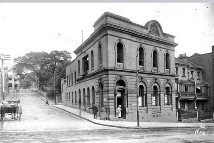
Before Blackwattle Bay and the tourist queues at today’s Sydney Fish Market, the city’s first purpose-built fish market sat hard against Woolloomooloo Bay. The City Council built it in the early 1870s (commonly dated 1871–72) to regulate a trade that had long mixed harbour-side hawking, boat sales and street cries of “Fish O!” with recurring complaints about quality and public health. The market stood in the Forbes / Plunkett / Bourke Streets precinct — a working harbour of fishers, coastal traders and timber yards.

The Eastern Fish Market (as Woolloomooloo became known) was extended in 1888 and 1893 until it covered the block bounded by Bourke, Plunkett, Forbes and Wilson Streets. A privately owned Southern Fish Market opened at Redfern in 1891; later the municipal City Fish Market at Haymarket drew trade away. The Woolloomooloo building was sold in 1911 and operations left the bay. The market structures were eventually demolished; the Astor apartments rose on the site in the 1960s. Fish marketing later centred on Haymarket and, from 1966, Blackwattle Bay — the lineage of today’s Sydney Fish Market — but Woolloomooloo remains where the city’s first formal fish market began.


Woolloomooloo Fish Markets - Woolloomooloo - NSW


Historic Eastern Fish Market building at Woolloomooloo


Scientology House – Castlereagh Street – Sydney – New South Wales

If you walk Castlereagh Street near Hyde Park and clock the Federation warehouse with the brick pilasters and that bronze-glazed front, you are looking at the Vickery Building — not a purpose-built church. Boot manufacturer Joseph Vickery & Co put it up in 1908 (architect Alfred Newman, Federation Free Classical). The Sydney Morning Herald of the day reckoned it would “considerably improve this portion of the city,” which tells you how industrial-commercial this stretch still felt.

The Church of Scientology bought the property in 1979, after which municipal inventories often listed it as Scientology House. A major heritage refurbishment and vertical expansion, finished 2014 for the Sydney Ideal Organisation, restored façade elements and added upper storeys. Whatever the present use, the fabric story is a 1908 commercial warehouse adapted and enlarged under later heritage controls.

Photographs here show the Castlereagh Street elevations and commemorative signage associated with the site.


The building at 201 Castlereagh Street, long known in city records as Scientology House, began life in 1908 as the Vickery Building for boot manufacturer Joseph Vickery & Co. Contemporary press praised the Federation Free Classical warehouse as an improvement to this industrial-commercial stretch of the city. Brick pilasters and a distinctive glazed façade still mark it as an early twentieth-century Castlereagh Street landmark.


The Church of Scientology acquired the property in 1979, after which municipal heritage inventories commonly listed it as Scientology House. A major heritage refurbishment and vertical expansion (completed 2014) restored historic façade elements and added upper storeys when the premises were fitted out as the Sydney Ideal Organisation. Whatever the present religious use, the fabric story is that of a 1908 commercial warehouse adapted and enlarged under later heritage controls.


Photographs here show the Castlereagh Street elevations and commemorative signage associated with the site.

Scientology House - Castlereagh Street - Sydney - New South Wales 


John Challis – Challis House – Martin Place


John Challis - Challis House - Martin Place - Sydney - New South Wales 


Martin Place between the GPO columns and the Cenotaph, the sandstone-and-bronze wall with the university’s name still quietly on it — that’s Challis House. Not a memorial chapel. An investment. The building at 4–10 Martin Place was erected for the University of Sydney from the Challis Bequest. Merchant and philanthropist John Henry Challis (1806–1880) left a major endowment (commonly cited as £276,000) that funded professorships and other university purposes; the Martin Place property was built to keep producing income for that legacy.

The first Challis House rose in 1906–1907 under architects Robertson and Marks with Government Architect Walter Liberty Vernon. Early lower-floor tenants included railway ticketing and the Government Tourist Bureau. In 1936–37 the building was substantially reconstructed with a new Art Deco sandstone, granite and bronze façade by Hennessey and Hennessey, skilfully folding in much of the earlier fabric. Further internal refurbishment followed in 1973. Challis House is listed on the NSW State Heritage Register.


The single photograph shows the Martin Place façade; its era is not obvious from the image.


West Street – Darlinghurst

West Street, Darlinghurst, is named for Thomas West, the emancipist millwright who in 1810 got Governor Macquarie’s backing to put a water-powered flour mill on the creek falling to Rushcutters Bay. West called the estate Barcom Glen after the Barcombe mills in Sussex. On 14 January 1812 Macquarie and Elizabeth came out to set the mill going and grind the first wheat — she was patron of the opening gift of grain. Macquarie later called it the first water mill in the immediate vicinity of the town. The mill worked into the 1830s; millstones survive in the Powerhouse collection. Aboriginal people continued to camp and gather along the glen — West’s Bush — well into the nineteenth century.

Adjoining land granted in the 1850s to the Sisters of Charity became St Vincent’s Hospital (purpose-built hospital opened 1870), which still dominates the ridge above. Parts of West Street were later closed or reshaped as the hospital and Barcom Avenue Reserve expanded; Boundary Street formalised the Paddington / Sydney edge along the buried creek line. A local heritage marker summarises the 1810 mill grant and the hospital/park succession — a caption cue, not the whole story.


First Sydney Exhibition Building – Prince Alfred Park – Central – Sydney – New South Wales

Walk south of Central into Prince Alfred Park and the lawns feel like they are waiting for something bigger than a lunchtime kickabout. They were. Sydney’s first purpose-built exhibition hall stood here — in what had been Cleveland Paddocks — years before the Domain got its Garden Palace. The Intercolonial Exhibition Building opened on 30 August 1870 for the Intercolonial Exhibition of General Industries and Arts, organised by the Agricultural Society of NSW to mark the centenary of Cook’s landing at Botany Bay and to rehearse colonial displays for overseas shows. All the Australian colonies and New Zealand were invited.

The park had been gazetted in the mid-1860s and named for Prince Alfred after his 1868 visit. City engineer Edward Bell designed the hall; Benjamin Backhouse laid out the grounds — the first Australian park designed around a major exhibition, ahead of Barnet’s 1879 Garden Palace and Melbourne’s Royal Exhibition Building of 1880. After 1870 the hall stayed busy with shows, concerts and later uses, including the Australian War Memorial museum collections from 1925 until they moved to Canberra in 1936.

The building came down in 1954. The park is still public open space; some of the nineteenth-century planting, including boundary Moreton Bay figs from the early layout, is part of its heritage character. The photographs here remember the lost hall — different building, different park, nine years earlier than the Garden Palace.


The First Sydney Exhibition Building
Prince Alfred Park 


To think, this was only demolished in the 1950’s.... to make way for a swimming Pool.... 


Windmills of Old Sydney


Windmills Of Old Sydney


It’s Hard To Believe That Sydney Was Once The City Of Windmills. There Were More Than 7 Along The Darlinghurst Ridge, 3 In the Government Domain & 1 At Miller’s Point. 


The Old Windmills of Sydney, also known as the Government Windmills, were a historic group of windmills that played a significant role in early colonial Sydney. Here's everything you need to know about the Old Windmills:


1. Establishment: The first windmill in Sydney was constructed in 1796 by convict labor. It was located on what is now Observatory Hill, near the current site of the Sydney Observatory. The windmill was built to meet the demand for flour in the growing colony.


2. Purpose: The windmills served as grinding mills for grain, primarily wheat, producing flour for the colony. At the time, grinding mills were crucial for food production, as they converted raw grain into a usable form.


3. Operations and Design: The windmills were traditional post mills, with a timber tower and a rotating cap that housed the grinding mechanism. They featured large sails attached to the cap, which were designed to catch the wind and turn the grinding stones inside.


4. Expansion: Over time, additional windmills were constructed near the original windmill on Observatory Hill. By the early 19th century, there were several windmills operating in the area, meeting the growing demand for flour.


5. Decline and Demolition: As the colony developed and technology advanced, the demand for windmills declined. The introduction of steam-powered mills and other industrial advancements made windmills less efficient and economical. By the mid-19th century, the Old Windmills had fallen into disrepair and were eventually demolished.


6. Legacy: Although the Old Windmills no longer exist, they hold historical significance as a reminder of the early colonial era and the importance of flour production in sustaining the colony. Observatory Hill, where the original windmill stood, is now a public park and offers panoramic views of Sydney Harbour.


7. Sydney Observatory: The site of the original windmill on Observatory Hill later became the location of the Sydney Observatory, which was established in 1858. The observatory played a crucial role in astronomical and meteorological observations and is still operational today.


While the Old Windmills of Sydney are no longer standing, their presence in the early years of the colony reflects the importance of food production and the influence of technology on the development of Sydney. Their legacy is remembered through historical accounts, images, and the site's transformation into Observatory Hill and the Sydney Observatory.


Boston's Windmill, also known as the Observatory Hill Windmill, is a historic landmark located in Sydney, Australia. It holds a significant place in the city's history and serves as a reminder of Sydney's colonial past and early industrial developments. Here's an overview of its history:

Construction and Purpose:

  • Boston's Windmill was built in 1828 by ex-convict John Boston on the western side of what is now known as Observatory Hill.
  • The windmill was constructed to meet the growing demand for flour in the colony. At the time, Sydney faced shortages of flour, and the windmill was intended to contribute to local food production.

Design and Operation:

  • The windmill was a three-story structure with white-painted timber cladding.
  • It was a smock mill, a type of windmill design with a sloping tower that could be rotated to face the prevailing wind direction.
  • The windmill was equipped with millstones and machinery for grinding grain into flour.

Challenges and Decline:

  • Despite its potential, Boston's Windmill faced challenges such as inconsistent wind patterns and competition from other mills.
  • The mill's output did not meet expectations, and John Boston's financial difficulties led to its closure in 1836.

Later Uses and Preservation:

  • After its closure as a working windmill, the structure was repurposed for various uses, including as a signal station for ships entering Sydney Harbour.
  • In the 1860s, the windmill was incorporated into the establishment of the Sydney Observatory.

Sydney Observatory:

  • The windmill tower was integrated into the design of the Sydney Observatory, which was established on Observatory Hill in the 1850s.
  • The windmill tower was used as a telescope dome and observatory building, enhancing the historical and scientific significance of the site.

Heritage and Preservation:

  • Boston's Windmill and the Sydney Observatory are recognized as heritage-listed sites.
  • The windmill's incorporation into the observatory highlights its historical value and its contribution to Sydney's early industrial and scientific developments.

Today, Boston's Windmill and its integration into the Sydney Observatory continue to reflect the city's evolving history. The site stands as a testament to Sydney's colonial past, technological progress, and the efforts of individuals like John Boston who contributed to the development of the city's infrastructure and industry.


In colonial Sydney, windmills played a crucial role in food production, grinding grains into flour to meet the growing needs of the population. These windmills were significant landmarks of their time, contributing to Sydney's development and economy. Here's an overview of the history of windmills in old Sydney:

1. Boston's Windmill (Observatory Hill Windmill):

  • Built in 1828 by ex-convict John Boston on what is now Observatory Hill.
  • The windmill aimed to address the colony's flour shortages and contribute to local food production.
  • It was a smock mill design with three stories and white-painted timber cladding.
  • The windmill's operation faced challenges, and it closed in 1836.
  • The windmill tower was later incorporated into the Sydney Observatory, enhancing its historical and scientific significance.

2. Rose's Windmill (Vaucluse Windmill):

  • Constructed in the 1810s by James Squire, a former convict turned brewer.
  • The windmill was situated in the Vaucluse area, in what is now Sydney's eastern suburbs.
  • It was used to grind grains for brewing and flour production.
  • The windmill was demolished in the 1850s, and the area's name, Vaucluse, is derived from the Latin "vallis clausa," meaning "hidden valley."

3. Greenway's Windmill (Mulgrave Windmill):

  • Designed by Francis Greenway, the colonial architect, and constructed in the late 1820s.
  • Located in the area known as Mulgrave Place (now Windsor), northwest of Sydney.
  • The windmill was part of the government's efforts to promote local flour production.
  • It was functional for several years but fell into disrepair and was eventually demolished.

4. Burnell's Windmill (Birkenhead Point Windmill):

  • Located at Birkenhead Point on the shores of Iron Cove.
  • Built by former convict John Burnell in the 1830s.
  • The windmill contributed to local grain processing and flour production.
  • The windmill's operation was short-lived, and it ceased functioning in the mid-1800s.

These windmills were important in ensuring a local supply of flour and grains in a growing colony, where imported goods were often scarce and expensive. Their historical significance lies not only in their practical role but also in their representation of Sydney's early industrial development and the efforts of individuals like John Boston, James Squire, and Francis Greenway who contributed to the city's growth. While most of these windmills no longer exist, they are remembered as important landmarks in Sydney's history.


The Widening Of William Street - East Sydney & Kings Cross


The Widening Of William Street - East Sydney & Kings Cross - New South Wales 


11


William Street borders on Woolloomooloo and Darlinghurst. 

In 1923, William Street was narrow and had very poor road conditions.

It was decided a resumption would take place.


209 a William Street Was the Saint Bernards home for working gentleman, it was three floors above shops and it offered 35 rooms and was built by Edith Walker

It was decided that a resumption would take place and property would be resented


The widening of William Street in Sydney refers to a significant infrastructure project undertaken to expand the width of William Street, a major thoroughfare in the city. Here's some information about the widening of William Street:


1. Background: William Street is a well-known street located in the eastern part of Sydney's central business district. It runs from Kings Cross through the heart of the city, eventually connecting to Hyde Park and the Domain.


2. Purpose: The project aimed to address the increasing traffic congestion and improve the flow of vehicles along William Street. The widening of the street was intended to accommodate the growing number of vehicles and enhance transportation efficiency.


3. Scope of Work: The widening project involved the expansion of the road width on both sides of William Street. This required acquiring adjacent properties and demolishing existing buildings along the street to create additional space for the widened road.


4. Construction: The construction process involved careful planning and coordination to minimize disruption to traffic and businesses along William Street. Temporary traffic management measures were implemented during the construction period to ensure the smooth flow of vehicles.


5. Pedestrian Enhancements: Along with the road widening, the project also aimed to improve pedestrian infrastructure. This included the construction of wider footpaths, installation of street furniture, and enhancement of pedestrian crossings for safer and more convenient walking experiences.


6. Completion and Impact: The widening of William Street was completed in stages, and the new road configuration was opened to traffic upon each section's completion. The project significantly increased the road capacity and helped alleviate traffic congestion in the area.


7. Urban Transformation: The widening of William Street not only improved traffic flow but also contributed to the urban transformation of the surrounding area. The expansion created opportunities for redevelopment and revitalization of adjacent properties, leading to the enhancement of the streetscape.


The widening of William Street was a major infrastructure project aimed at addressing traffic congestion and improving transportation efficiency in Sydney's central business district. The completed project resulted in a wider road and improved pedestrian infrastructure, benefitting both motorists and pedestrians.


VICTORIA STREET 

ABOUT WHERE HOLIDAY INN IS TODAY 


This Is The English Scottish and Australian Bank on 255 William street. It was lost when William street was widened in 1926


The Police Offices - George Street - Sydney - New South Wales


The Police Offices - George Street - Sydney - New South Wales 


Before The End Of Transportation Convicts Would  Be Marched Up From Being Unloaded At Circular Quay

Up The Dusty Stretch To The Police Offices Where The Queen Victoria Building Now Stands 


The Old Police Office on George Street in Sydney refers to a historic building that served as a police headquarters in the early days of the city. Here's some information about the old police office:


1. Establishment: The Old Police Office was constructed in 1825 and located on the corner of George Street and Essex Street (now demolished) in Sydney, New South Wales, Australia. It was built during the colonial period when Sydney was still a British settlement.


2. Function: The building served as the central police headquarters and administrative center for law enforcement in Sydney. It housed various police departments, including offices for the chief police magistrate, superintendent of police, and other police officers.


3. Design and Architecture: The Old Police Office was designed in the Georgian architectural style, which was popular during the early colonial period. It featured a distinctive sandstone facade with arched windows and a prominent entrance. The building reflected the architectural tastes of the time and added to the visual character of George Street.


4. Law and Order: The Old Police Office played a vital role in maintaining law and order in early Sydney. It served as a hub for police operations, including the processing of criminals, holding of prisoners, and coordination of policing activities. The building also housed courtrooms where legal proceedings were conducted.


5. Historical Significance: The Old Police Office holds historical significance as a symbol of early law enforcement in Sydney. It represents the establishment of formal policing structures in the growing colony and reflects the efforts to maintain order and security in the city.


6. Demolition: Despite its historical significance, the Old Police Office was eventually demolished in the early 20th century as part of urban redevelopment and modernization of the area. The demolition of the building made way for new developments and altered the streetscape of George Street.


While the original Old Police Office no longer stands, the history of its existence and its role in the early law enforcement efforts in Sydney are remembered through historical records and accounts. The site of the former building now forms part of the ongoing development and transformation of the George Street precinct in the city.