Search This Blog

Sunday, March 14, 2021

Hay Street – Haymarket – Chinatown – Sydney – New South Wales


Hay Street - Haymarket - Sydney - New South Wales 

Hay Street runs through Haymarket, the valley south of Brickfield Hill that Governor Darling’s administration set aside in 1829 for cattle and corn markets — a pause-point for farmers’ carts before the haul into town. The place-name Haymarket stuck; City of Sydney later controlled the market lands. Belmore Markets (fruit and vegetables, from 1869 on the old cattle-market ground) and adjoining Paddy’s markets drew produce traders, pubs and Saturday-night crowds; market buildings on the wider site later cycled through circus, hippodrome and Capitol Theatre uses.

Chinese merchants and gardeners clustered here from the 1870s, forming what historians call Sydney’s second Chinatown after The Rocks. When municipal markets shifted toward Darling Harbour in the early twentieth century, Chinese commerce reconcentrated around Dixon Street; from the 1970s–80s that precinct was promoted as Chinatown, while Hay, Campbell and neighbouring streets kept market memory, fine-grain shops and civic buildings (including the Corporation Building / former markets administration fabric nearby). Hay Street today is still a Chinatown–Haymarket spine of heritage shopfronts, light rail and night-time economy.

Photographs here document Hay Street façades and the Haymarket setting.


181–187 Hay Street – Haymarket


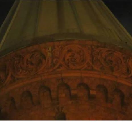
Haymarket’s little terracotta-and-brick corner tower is easy to walk past on the way to Paddy’s or the Capitol — which is a shame, because it is one of the most highly decorated small municipal buildings Sydney ever put up. 181–187 Hay Street, better known as the Corporation Building (also the Municipal Building), was designed in 1892 by City Architect George McRae for Sydney Municipal Council and built in 1893–95 as a service building for the new Belmore Markets. It gave the market clerk and produce agents offices, refreshment rooms and toilets.

The Federation Anglo-Dutch façade is rich in face brick, sandstone and glazed terracotta, with that distinctive corner tower. Together with neighbours such as the Capitol Theatre, Haymarket Chambers and the Palace Hotel, it forms a late-Victorian / Edwardian streetscape tied to markets, the railway terminus and nearby retail. The building is on the NSW State Heritage Register (SHR 00693). City of Sydney conservation works completed in 2022 restored degraded façade detailing and rebuilt the Hay/Parker Street entrance in original character.

Photographs here document the Hay Street elevations and ornamental detail of McRae’s Corporation Building.


Sunday, March 7, 2021

Oxford Street - Darlinghurst - Sydney - New South Wales - 1788 Onwards


Oxford Street - Darlinghurst - Sydney - New South Wales - 1788 Onwards


Oxford Street still rides a Gadigal ridgeline path (muru) that long linked the harbour country around Sydney Cove with the southern headland. In 1803 a track to the South Head signal station was cleared under surgeon John Harris; Governor Macquarie upgraded it in 1811 for wheeled traffic as South Head Road. The Old South Head Road became the approach to villa estates on Woolloomooloo Hill / Darlinghurst and to Paddington; New South Head Road (from 1831) later took much of the harbour-side carriage traffic.

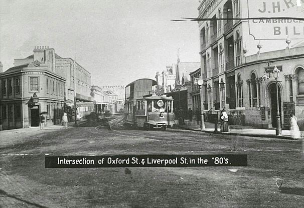
The busy commercial stretch between Hyde Park and Paddington was renamed Oxford Street in the mid-1870s (gazettal commonly cited 1875), after London shopping-street fame. Trams, department stores and Federation rebuilding after early-twentieth-century widening (Lord Mayor Allen Taylor scheme; Taylor Square formed 1907–08) remade the northern side. Later public culture along the Darlinghurst golden mile added another layer. Beyond Bondi Junction the older name Old South Head Road still runs toward Watsons Bay.

Photographs here document the Oxford Street / Old South Head Road spine from the city toward the eastern suburbs.

Oxford Street At The Liverpool Street Junction Circa 1901


Monday, March 1, 2021

Original Villas Of Woolloomooloo Hill, Potts Point & Elizabeth Bay - 17 Allotments - Granted By Governor Darling


Original Villas Of Woolloomooloo Hill, Potts Point & Elizabeth Bay - 17 Allotments - Granted By Governor Darling

If you stand on the Darlinghurst ridge and squint, you can still feel Governor Ralph Darling’s idea. In the late 1820s he picked the height then called Woolloomooloo Hill (soon Darlinghurst, associated with Eliza Darling) for a belt of gentlemen’s villas looking down on the town. Between about 1828 and 1831 he issued roughly seventeen grants of eight to ten acres, mainly to senior officials and favoured free settlers. Conditions were strict: plans needed his approval; each allotment was limited to a single substantial residence (commonly to a stated minimum of £1,000); houses were to face the town where practicable and sit in landscaped grounds.

Among the houses raised on those grants were places still remembered in street and suburb names — Craigend (Sir Thomas Mitchell), Barham (Edward Deas Thomson), Springfield, Rosebank, Orwell, Tusculum, Rockwall, Grantham, Brougham, Kellett and others. Most came down from the 1890s onward for terraces and flats. Only a handful survive: Barham inside SCEGGS Darlinghurst, Tusculum and Rockwall on the Potts Point ridge. Elizabeth Bay House sits in the same villa landscape story, though on its own closely related estate narrative.

watercolour of Potts Point


Woolloomooloo Boat Sheds - watercolour - Undated


ELIZABETH BAY HOUSE 
House


TUSCULUM 


ROCKWALL
BARHAM. 


GRANTHAM

BROUGHAM LODGE 
KELLETT HOUSE