Search This Blog

Tuesday, March 3, 2020

Dalley Street - Queen's Place - Charlotte Place - Laneways - Sydney - New South Wales


Dalley Street - Laneways - Sydney - NSW


What's In A Name? Dalley Street, Named After Politician Victor Dalley, Was Once Called Queen's Place. And It's Continuation Across George Street Was Called Charlotte Place, (Now Grosvenor Street). Queen Charlotte Was George III Queen. Queen's Court (Dalley Street) Was Part Of A Warren Of Tiny Lanes & Courtyards That Grew Up Alongside The Banks Of The Tank Stream between The "Official" George & Pitt Streets. 


Underwood Street - Laneways - Sydney - New South Wales


Underwood Street - Laneways - Sydney - NSW


Here Is Another Reminder Of How Remote The Original Waterfront Has Become, As This Is The Place Where James Underwood Built Sydney's First Commercial Shipyard In 1798. The Red Brick Building At The Bend In The Lane Is Unusual, Employing An Architectural Style That Was More Commonly Used In Domestic Apartment Buildings in The 1930's & 1940's 


Bulletin Place - Laneways - Sydney - New South Wales


Bulletin Place - Laneways - Sydney - NSW


The Basement Has Long Been A Favourite Jazz Venue In The City. Beyond This, Warehouses & Stores From The Mid 19th Century Preserve A Little Enclave Of Olde Sydney. The Bulletin Newspaper Was Published Here From 1880, & Writers Such As Henry Lawson & A B Paterson Would Have Frequented This Little Street. 

This Lane Possibly inspired The Lines Of Patterson's Famous Poem 
"Clancy Of The Overflow" 
About Dingy Offices And Folk With 
"Stunted Forms & Weedy, For Townsfolk Have No Time To Grow, They Have No Time To Waste"


Reiby Place - Macquarie Place - Sydney - New South Wales


Reiby Place - Near Macquarie Place - Sydney - NSW 


Today Reiby Place Is Lined With Slick Glass & Concrete, But It's Name Commemorates One Of The City's Earliest Entrepeneurs. 

Before This Area Was Drained, Thomas & Mary Reiby Had A House On the Waterfront Macquarie Place. Mary Reiby, Convicted For Horse Stealing, Became A Wealthy & Respected Widow, & In 1817 Her House Became The First Premises Of Australia's First Bank, The Bank Of New South Wales.

Mary Reiby's Face Is On The $20 Note.


Mary Reiby 1777 to 1855 was a convict who became a highly successful business woman was interested in hotels, trading, shipping, farming in city buildings.

She briefly owns the land around Argyle stores in 1828. Mary Reiby was a governor of the free Grammar School and a founding member of the bank of New South Wales, as well as an active in church and charity work


Loftus Lane - Circular Quay - Sydney - New South Wales


Loftus Lane - Circular Quay - Sydney - NSW 


For Most Of Its Life This Laneway Has Served As The Entrance To The Buildings On Loftus Street, Housing Custom Agents, Shipping Brokers & Wool Buyers. The Old Three Storey Sandstone Building On The Right, Which Forms The Rear Of The Gallipoli Club, Was Built In 1876. This & Hinchcliffs Are The Only Remaining Woolstores In The Circular Quay Precinct. 


Customs House Lane - Circular Quay - Sydney - New South Wales

If you duck off Circular Quay into the tight grid between Alfred, Loftus and Young Streets, you’re in the old customs-and-wool pocket of the working port. Customs House Lane sits hard against Sydney’s Customs House — the bureaucratic heart of the quay when wool and general cargo still came alongside. Colonial Architect Mortimer Lewis designed the original Greek Revival building; construction ran 1843–45 on reclaimed foreshore. Overcrowding and damp pushed James Barnet to enlarge and rebuild in the 1880s (wings, another floor, the portico), with later twentieth-century alterations. After Federation the Commonwealth ran customs from here until operations wound down around 1988–90. Today it’s a City of Sydney cultural and library venue — not an active customs office.

On the south-west of the lane precinct, Hinchcliff’s stone wool store (Hinchcliff House, 5–7 Young Street) survives from the staple-export years. Andrew Hinchcliff’s firm built the stone store about 1860 (an earlier iron shed of 1845; a matching late-1880s addition). Mid-century the Society of St Vincent de Paul used it as Ozanam House and, from 1952, part of the Matthew Talbot Hostel for homeless men before the hostel moved on. The façade hoists still read as wool-bale kit if you know what you’re looking at.

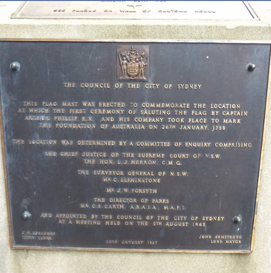
Together the customs house and woolstore tell Circular Quay’s shift from working port to civic waterfront. Soften any claim that a particular Loftus Street flagpole marks the exact 1788 flag-raising site — popular tradition varies; treat flag symbolism as commemorative unless a heritage panel is quoted. Photographs here cover Customs House, Hinchcliff House / the lane, and Circular Quay streetscape.


Customs house was where shipping was cleared and goods passing through the Port of Sydney will text for sale or export.
When the port was busy the house was crowded and noisy, a scene of raised tempers, delays in disputed dealings.

The six story colonnaded building you see today evolve through several phases of expansion between 1845 and 1917.
On Loftus Street alongside the house, union Jack flies permanently on the site where the first British flag was raised.



Phillip Lane – Off Phillip Street – Sydney – New South Wales


Phillip Lane - Off Phillip Street - Sydney - NSW

Phillip Lane Is The Last Survivor Of Several Laneways That Were Established In The 1840's To Service Macquarie Street House. The White Astor Apartments On The Left Were Built In 1923, & An Early Example Of Fashionable Apartment Living In the City. 
On The Right Is The Rear Of The Chief Secretary's Building, Occupied From 1878. The Laneway's Low Sandstone Archway, Remnant Sandstone Guttering & Cobblestone Paving Echo A Past Kind Of Streetscape  That Has All But Disappeared from the City 


Across Phillip Street Is The Museum of Sydney, Which Is The Location of The Very First Original Government House. 


Sunday, March 1, 2020

Maps of Sydney – From January 1788 Onwards


Sydneys earliest maps record the establishment and growth of the colonial settlement founded at Warrane (Sydney Cove) in 1788. Early surveyors charted the harbour, shoreline and developing streets as the town expanded. Comparing these maps helps show how Sydney’s landscape changed from the first years of European settlement.


Maps Of Sydney