Search This Blog

Wednesday, December 7, 2016

Richmond Church and Rectory

If you drive out to the Hawkesbury and come into Richmond along Windsor Street, St Peter’s sits on the rise above Pugh’s Lagoon as if Macquarie had planted it there — which, in a way, he did. This is one of his five Macquarie Towns. On the Hawkesbury tours of 1810–11 he chose an elevated bank for church, schoolhouse and burial ground; on 10 January 1811 the site was marked out with strong posts. An early schoolhouse-chapel served the town until a purpose-built church was needed.

The present Colonial Georgian church was designed by Francis Clarke and built by James Atkinson between the later 1830s and 1841. Bishop William Grant Broughton consecrated it on 15 July 1841. The picturesque rectory, also by Clarke, was completed in 1847. Edmund Blacket later altered the church — porch 1850, chancel mid-1850s — and remodelled the rectory in 1863. The group — church, rectory, school hall, cemetery and stables — sits in a park-like setting overlooking the lowlands and is listed on the NSW State Heritage Register.

Photographs here show the Richmond church and rectory group in the Hawkesbury landscape. This is St Peter’s, Richmond (Hawkesbury), NSW — not St Luke’s, Richmond, Tasmania.


Tuesday, December 6, 2016

King Street, Sydney – Looking West

King Street cuts east–west through the CBD — Domain / Macquarie Street at one end, the land falling toward Darling Harbour / Cockle Bay at the other — named for Philip Gidley King, First Fleet officer and Governor of New South Wales (1800–1806). Nineteenth-century “looking west” views catch shopfronts, hotels and horse traffic on the descending ridge — the commercial grain between George, Pitt, Castlereagh and Elizabeth.

The street stayed a retail and theatre-adjacent corridor well into the twentieth century, rebuilt after fires and boom cycles. Images here belong to that looking-west documentary habit rather than to one surviving landmark façade. Caption by identifiable corners, signage or vehicles where you can read them — and don’t confuse this CBD King Street with Newtown’s King Street.


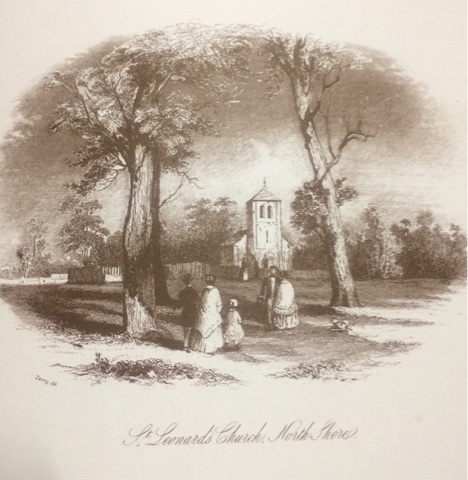
St Thomas’ Anglican Church, North Sydney (historic St Leonards)

The live title says “St Leonard’s Church, North Shore” — but the Anglican parish church of the old township of St Leonards (today’s North Sydney) is St Thomas’, on McLaren / Church Streets. Land was set aside as the north shore settled in the 1820s–40s. The first St Thomas church, generally attributed to Conrad Martens, was begun in the early 1840s, opened in 1846, and tied to Bishop Broughton’s early pastoral work on this side of the harbour. Martens’s carved font is still reported in use.

Population growth demanded a larger building. Edmund Blacket designed a new Gothic Revival church; the foundation stone for the nave and tower stage was laid in 1881, and the completed church was dedicated in 1884 (works continuing under Cyril Blacket after Edmund’s death in 1883). Built of locally quarried stone, St Thomas’ is among the longest Anglican parish churches in New South Wales. The proposed tower was never fully realised as originally intended.

Prefer the correct dedication St Thomas’ in titles and captions; “St Leonards” properly names the historic township/district.


Mm

The Anglican parish church of the old township of St Leonards — today’s North Sydney — is St Thomas’ Church on McLaren / Church Streets, not a separate surviving building named “St Leonard’s Church.” Land was set aside as the north shore settled in the 1820s–40s. The first St Thomas’ church, generally attributed to Conrad Martens, was begun in the early 1840s, opened in 1846, and associated with Bishop Broughton’s early pastoral work on the north side of the harbour. Martens’s carved font is still reported in use.

Population growth required a larger building. Edmund Blacket designed a new Gothic Revival church; the foundation stone for the nave and tower stage was laid in 1881, and the completed church was dedicated in 1884 (works continuing under Cyril Blacket after Edmund’s death in 1883). Built of locally quarried stone, St Thomas’ is among the longest Anglican parish churches in New South Wales. The proposed tower was never fully realised as originally intended.

Photographs here appear to show that North Shore parish church and its nineteenth-century fabric. Prefer the correct dedication St Thomas’ in titles and captions; “St Leonards” properly names the historic township/district.


Courthouse and Scotch Church – Parramatta

The old prints call it “Courthouse and Scotch Church, Parramatta” as if they were a pair you could still walk between. You can’t — one is mostly gone, the other left town. Those colonial views show two neighbouring civic buildings near the corner of Church and George Streets: the second Parramatta Courthouse and the Scots’ (Presbyterian) Church, later known as St Andrew’s.

The courthouse was a Greek Revival sandstone building associated with Colonial Architect Mortimer Lewis and builders James Houison and Nathaniel Payten, put up in the late 1830s (opened for use in the late 1830s–1840) and extended mid-century. It served until a later courthouse generation replaced it; only fragments (notably a sandstone wall and cell block behind the George Street frontage) survive from the Lewis complex. Some of the old courthouse columns were reused in the Boer War Memorial in Parramatta Park.

The Scotch Church — St Andrew’s Presbyterian Church — was a Victorian Gothic landmark on Church Street. Construction began about 1840 (architect James Hume, with local associations to James Houison) and the church was completed in the 1840s. When a larger St Andrew’s opened elsewhere in Parramatta in the 1920s, the old “Auld Kirk” was dismantled and re-erected at McKern Street, Wentworthville, where it was dedicated in 1928. These images therefore record a nineteenth-century streetscape pairing that no longer stands together in central Parramatta.

P


The Parramatta Courthouse and Scotch Church were important civic and religious buildings in the colonial town. The Scotch Church served Parramatta’s Presbyterian community, while the courthouse supported the town’s growing judicial and administrative life. Together, they reflect Parramatta’s development as a major centre in nineteenth-century New South Wales.


Garden Island, Pinchgut, and Clarke's Island, Seen from Rose Bay


Garden Island, Pinchgut, and Clarke’s Island lie in Sydney Harbour, opposite the eastern suburbs and visible from Rose Bay. Garden Island became an important naval and maritime site, while Pinchgut—now Fort Denison—was fortified in the nineteenth century. Clarke’s Island preserves another layer of the harbour’s colonial history and changing place-names.


Entrance to Sydney Harbour – North Head

Stand on North Head on a clear day and you understand why every colonial chart and postcard obsesses over “the Heads.” This is the northern side of the seaward entrance to Port Jackson — Sydney Harbour — opposite South Head, near Manly. Contemporary park interpretation uses Aboriginal names such as Car-rang-gel (and related Gayemagal spellings); use published park or council forms carefully. From early colonial times the headland was a landmark for shipping and a vantage for signal and lookout posts — historic views “from the Flagstaff” look out across the Heads toward the ocean and the harbour mouth.

In 1832 the colonial government reserved much of North Head for quarantine. The North Head Quarantine Station operated from 1832 until 1984, receiving ships and passengers whose health threatened the colony and later the nation. It is among Australia’s most intact quarantine complexes and is listed on both the National Heritage List and the NSW State Heritage Register (as part of the wider North Head / Sydney Harbour National Park landscape). After closure the station passed to NSW National Parks and Wildlife Service; the leased tourism precinct is widely known as Q Station, still inside the national park and under heritage controls.

North Head also carries layers of Aboriginal Country, twentieth-century defence works, and remnant bushland of high conservation value. Treat this post as an entrance-to-the-harbour essay: keep the Flagstaff viewpoint if your images are historic prints, and let quarantine and national-park history give the place depth without inventing ship names or outbreak tallies.


Monday, November 14, 2016

Admiralty House - Kirabilli - Governor General's Residence


I Guess That Everyone   Knows That Adiralty House Is The Residence Of TheGovernor  General When In Sydney.


Originally The Land Was Acquired By The New South Wales Government In 1885 As A Residence For The British Officers In Command Of The Australian Naval Station. 
At That Time London Took Responsibility For Defence On The Southern Continent. A Dozen Admirals Had Resided There  Up Until 1913 When The Royal Australian Navy Was Established.


Back in 1806 When Kiribilli Was Wild And Uninhaited, Robert Campbell Bought The Property For a Few Pounds. 


It Surprises People Today That Kirribilli Point Was Referred To As "Russian Point". This Began in 1814 When The Russian Shhip SUVOROV Called In To Port Jackson. 


Colonnaded stone building, which which explains the garden dominate the Kirribilli, and has since 1916 been a resident of Australia’s governor general.

The house was bought in 1885 by the state of New South Wales as a residence for the naval commander in chief. Earlier the house of been described as having a white Veranda, spacious entrance hall, drawing and dining rooms, 10 bedrooms, and the usual rooms in the main part of the house for large courtyard, seventh rooms, kitchen stables etc with an abundant water supply which never fails in the driest weather.

To make this residence fit the British Admiral grand proportions. Did therefore came like a thunderclap to the state of Florida keys from the second last at McHughes it, for George King Cole, struck his black bear and handed the residents over to the Commonwealth.


Thursday, November 3, 2016

Francis Greenway’s Public Fountain – Bent & Spring Street

Under Governor Lachlan Macquarie, Francis Greenway designed a sandstone Doric public fountain for Macquarie Place that small civic triangle that marked the administrative heart of early Sydney. Built about 1819–20 by stonemason Edward Cureton (with taste often credited also to Elizabeth Macquarie), it stood on the western side of the reserve so townspeople could draw water without entering the Governor’s Domain. The Bent and Spring Streets corner sits in the same colonial civic precinct; period descriptions put the fountain in Macquarie Place, not as a free-standing ornament mid-intersection.

It was one of Greenway’s civic works from the Macquarie years — a period Commissioner John Thomas Bigge famously called extravagant. By the 1880s the fountain was dilapidated; it was demolished around 1883–87 and replaced by the statue of merchant and pastoralist Thomas Sutcliffe Mort that still occupies the western corner. No Greenway fountain fabric survives above ground.

Photographs here relate to the Macquarie Place site and the memory of Greenway’s lost Doric fountain.