Search This Blog

Thursday, October 22, 2015

Darling Harbour Creek


Darling Harbour Creek
A water course which passed through a tiny settlement of brickmakers late in 1788 began in the vicinity of the intersection of Riley and Foveaux Streets and flowed along the line of Sophia Street, then north in front of the Albion Brewery (Centennial Plaza is built on the brewery site) and through what today is Belmore Park. The section of Hay Street to the east of George Street, which was added after the creek was turned into an underground drain, follows the path taken by the creek to the marshes which encircled the head of the Cockle Bay (Darling Harbour) where the Entertainment Centre is today.

In the 1880s, Quay Street extended north as Lackey Street to the Darling Harbour railway goods yard built around a semicircular wharf at the head of Cockle Bay. A tributary of the main creek began as a spring near present day Hills Reserve in Surry Hills. Little Albion Street follows the path of the creek which cascaded down the hillside on the western side of Crown Street in what became known as Frog Hollow. This small valley was a notorious hideout for criminals in Victorian Sydney. UBD Map 3 Ref K 15

Wests Creek, Rushcutters Bay


Wests Creek, Rushcutters Bay
This creek which still enters Rushcutters Bay but via a concrete drainage channel today once flowed through what was known by the exotic name of the Valley of La Crozia. Located within the 40-acre (16.2 hectare) grant of William Thomas, the steep, picturesque valley has also been known as West's Bush and Barnum Glen. West's Creek, which has also appeared on maps over the years as La Crozia Creek and Rushcutters Creek, rose near present day Chisholm and Sims Streets, Darlinghurst and flowed through a series of races, pools and falls. The lower section, which flowed through the 70-acre grant of Thomas West which was located south east of Bayswater Road, joined another creek which today flows through Trumper Park and enters Rushcutters Bay via a concrete channel.

The Valley of La Crozia attracted weekend picnickers from all parts of Sydney in the early years of the 19th century. Though the upper section of the creek has long since dried up, its path is still recalled in the top end of Barcom Avenue, the whole of Boundary Street (above), Paddington and the eastern section of McLachlan Avenue which follow what became its dried up bed in the 1860s. The valley and a number of Chinese market gardens below the creek on the flats were subdivided and sold under the name of Barcom Glen, a corruption of the latter name Barnum Glen, in the 1880s. UBD Map 4 Ref L 14 

Black Wattle Swamp Creek


Black Wattle Swamp Creek

A bridge took Parramatta Street (now Broadway) over Black Wattle Swamp Creek (later called Blackwattle Creek), an important watercourse in Sydney's colonial days. Black Wattle Swamp Creek rose in a swamp where Prince Alfred Park is today and passed the old brewery on Broadway - it was the brewery's water supply and the reason for the plant being located there. The creek then followed the line of Blackfriars Street, entering Blackwattle Bay in a large swamp where the Sydney City Council Depot in William Henry Street now stands.

A tributary of Black Wattle Swamp Creek had its source beyond Erskineville Railway Station near the corner of Ashmore Street and Binning Lane. The railway corridor south was in fact built alongside the creek. The northern boundary of the Eveleigh Railway Workshops followed the creek. Boundary Lane, Boundary Street and Smithers Street follow the line of the creek.

Palmers Creek - East Sydney


Palmer's Creek, East Sydney
Though there are no records to indicate the existence of a creek by that name, it is not only likely but almost certain that the creek which once existed to the east of what is now The Domain on the western extremity of the city of Sydney was called Palmers Creek. The reason for this presumption is that it flowed into Palmers Cove, now Woolloomooloo Bay.

It was common practice among early colonial governors to give a creek the same name as the bay it flowed into. The name honours John Palmer, purser of HMS Sirius, one of a number of first fleeters who were buried in and have a marked grave in St. Johns Cemetery, Parramatta. Palmer, the colony's first Commissary, was granted the land through which the creek flowed. It has also been called Yurong Creek, perhaps its Aboriginal name and the reason why the street which followed its the western bank was called Yurong Street.

The creek rose in the vicinity of the intersection of present day Forbes and Bourke Streets. From this point it flowed north westerly down the hillside crossing Crown Street near Liverpool Lane. It then continued north towards the corner of Boomerang Place and William Street where it then followed the line of present day Sir John Young Crescent to enter Palmers Cove at its head.

In addition to the un-named squiggly line on contemporary maps, the existence of the creek is recalled in Stream Street (above), a curved laneway in East Sydney between Yurong and Stanley Lanes. Its shape and name are evidence that it follows the course of a small section of the creek as it passed through the area. The western section of Busby Lane also follows the line of the creek. A short tributary of the creek which rose in the vicinity of the site of Sydney Grammar School in College Street flowed along what now is the eastern edge of the fragrance garden of Phillip Park, entering the main creek at the northern corner of Busby Lane.
UBD Map 3 Ref K 15


Wuganmagulyav Creek - Farm Cove


Wuganmagulya Creek
After The Tank Stream, the creek which flowed into Farm Cove (Wuganmagulya) was the most important waterway to the early colonists of Sydney as it provided the water for the colony's farm located within the grounds of what is today the Royal Botanical Gardens. The root vegetables grown there thrived, but such was not the case with cereal crops about which Gov. Phillip, in his report of 28th September, 1788, said, "very little of the English wheat had vegetated and a very considerable quantity of the barley and many seeds had rotten in the ground ... all the barley and wheat likewise destroyed by the weevil."

The first fleeters weren't the first humans to utilise the land surrounding the small creek, however. The Aborigines appear to have used it as a meeting place for the various groups up and down Port Jackson long before the arrival of the white man, as they held a corroborree there during the first years of the colony. Corroborees were only held at set meeting places.

Farm Cove Creek is today the only watercourse in the inner city area which not only still flows but follows its original course as it wends its way through the Botanical Gardens.


Brickfield creek -


brickfield creek

Early colonial records indicate that a simple log bridge carried the road to Parramatta across the main creek near the Brickfields settlement's brick kilns. First marked on a map dated 1891, this bridge was located somewhere near the intersection of Hay and Pitt Streets. The section of Pitt Street between Hay Street and Railway Square was originally the beginning of Parramatta Road which began at the bridge.

According to a map dated 1802 drawn by French explorer Francois Peron, a bridge also existed over a small creek which flowed into Darling Harbour on its western side. That bridge was located where the flyover takes the Western Distributor over Pyrmont Street. The path which crossed the creek at the bridge provided access to the farm of Surgeon John Harris and followed the line of Harris Street. The creek is believed to have had its source within the site of the Sydney Institute of Technology, Ultimo. It is now an underground drain.
UBD Map 3 Ref B 14

Tuesday, October 20, 2015

Sydney - The 1860's

Amongst The Architects in 1850 There Were 

- The Lewis Family
- The Hallens
- The Housins 
- The Ginns 

But The One Who Would Become
as Important As Francis Greenway at The Beginning was EDMUND BLACKET. He Became An Australian In 1842 When He And His Wife Came Ashore From
the Emigrant Ship "Eden"


In 1859, A Seperate Colony Of Queenzland Was Created And Sydney..... and The Colony Of New Sputh Wales Found Itself A Third Of The Size It Had Been. 

So The Conaequences Led Business in Sydney Into Mini Depression. 


By 1850 The Early Colonial Period In Sydney And Australia Was Coming To An  End. New South Had Started As A. Convict Settlement, But By 1850 Transportation


George McCrae - New South Wales Colonial Architect - Sydney Municipality Building


Sydney Municipality Building


This Building Waa Designed By The colonial architect George McCrae And Was Built In 1896. He Had Been Appointed As The Head Colonial Architect For The City Of Sydney During The Golden Era Of the Victorian Era. 

George McCrae Was Also The Architect behind The Design Of The queen Victoria Building. & Would You believe  He Wet as Far As Designing Four Different Styles For The "Queen Victoria Markets" Which We Now Call The Queen Victoria Building 
George McCrae Did A Gothic Revival, Queen Anne Style,  Renaissance & Romanesque. I wonder where His Other versions  Of The Queen Victoria Building Are Ok If They've Ever Seen the Light When The  Romanesque Style Was Decided Upon. 


Sydney Centennial - 1888 - A Coming Of Age


1888 was The Summer Of The Height Of The Victorian Era In Old Sudney Town As It Came Into It's Own. 

It Was. A Year Of Celebrations For Sydney As It reached Is First Milestone Of 100 Years Of Settlement From The Furst Fleet Arriving With Captain Arthur Phillip In 1788. 

All The Builders Were Making Every Human Effort To Have Their Buildings Finished In That Year So Those Maguc numerals of 1888 Could Be Carved Iver Doorways, And Carved Into The Centrepiece Stones Of Their Magnificent Achievements. 

By The End Of The Centennial Year 1888, Sydney City Had Grown To 2,645 Acres, Amd There was Scarcely Any Building Left That Was Made Out Of Timber 

Waterloo Congregational Church


The Waterloo Comgregational  Church 

103 Botany Road.....  Waterloo 


This Is What The Building Looked Like In1865.  ItS No Longer A. Congregational Church 


Friday, October 16, 2015

Sydney Garden Palace after The Fire


Sydney GARDEN PALACE 
The Most Significant & Magnificent Building Ever In Australia. Then And There Is Nothing Now That Could Conpete With The Magnificent Roman 


The Sydney Garden Palace Gates were part of the entrance to the Sydney Garden Palace, a magnificent structure that once stood in the Royal Botanic Garden of Sydney, Australia. The gates are a remnant of the Garden Palace, which was a grand exhibition building that showcased the technological and cultural achievements of the late 19th century. Here's more information about the Sydney Garden Palace Gates:

The Garden Palace:

  • The Sydney Garden Palace was a vast exhibition building constructed for the Sydney International Exhibition of 1879. The building was designed by colonial architect James Barnet and was situated within the Royal Botanic Garden.
  • The Garden Palace was an impressive structure made of glass and iron, and it covered an enormous area. It housed a wide variety of exhibits, including displays of art, industry, science, and technology.

Gates and Entrance:

  • The entrance to the Sydney Garden Palace was marked by grand gates that led visitors into the exhibition building.
  • These gates were an integral part of the overall design, serving as an introduction to the opulent architecture and cultural treasures within the Garden Palace.

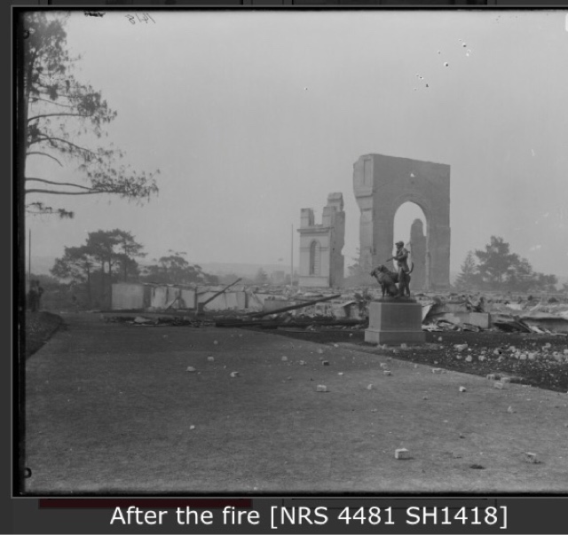
Destruction and Legacy:

  • Tragically, the Sydney Garden Palace was destroyed by a fire on September 22, 1882, just a few years after the exhibition. The fire was a devastating loss, as the Garden Palace housed numerous irreplaceable artifacts and exhibits.
  • The only remaining physical remnant of the Garden Palace is the sandstone and iron gates that once welcomed visitors into the grand exhibition building.

Current Location:

  • The surviving gates were removed from their original location at the site of the Garden Palace's entrance and repositioned elsewhere in the Royal Botanic Garden.
  • The gates serve as a historical artifact and a reminder of the grandeur that once existed on the grounds. They are an enduring link to a significant event in Sydney's history.

Cultural Significance:

  • The Sydney Garden Palace and its gates hold cultural and historical importance, representing a brief yet impactful moment in Sydney's past.
  • The gates symbolize the aspirations, achievements, and ultimately the loss associated with the Garden Palace and the exhibition it hosted.

Heritage Preservation:

  • The surviving gates are carefully preserved to ensure their historical significance is not lost. They serve as a tangible connection to an event that showcased the global ambitions of a growing colonial city.

The Sydney Garden Palace Gates stand as a poignant reminder of an ambitious project that sought to celebrate progress and innovation. While the grand exhibition building itself was lost to fire, these gates endure as a lasting testament to the cultural, technological, and architectural aspirations of 19th-century Sydney.


Governor Darling Announces 19 Counties - 1829

  It Was In 1829, That Governor Darling Announced 19 Counties Within New South Wales 


Thursday, October 8, 2015

Sydney Garden Palace - Part 2


Sydney Garden Palace - Part 2 


The Pictures Show Here Are From
the Great Exhibition... The Expo Of 1888. You May Recall That Exactly 100 Years Later In 1988 The World Expo Was Held In Brisbane Queensland. 


It Would've Been A Grand Event To See


The Sydney Crystal Garden Palace and The Great Exhibition of 1851


There are a few photos of the Crystal palace Located at the Royal Botanic Gardens in Sydney Australia. This magnificent structure was built to hole the World Expo in the 1880's. Unfortunately within a couple years of it being built, it burnt down.
It appears to be one of the most magnificent buildings in Sydney for the time, far outweighing the Queen Victroria building etc and other buildings in Sydney of that era. There are only a few photos left.


the Palace was composed almost entirely of iron and glass with wood used only in the fittings and floorboards. The construction used 2300 cast-iron girders, 358 wrought-iron trusses to support the roof, 325 kilometres of sash bars supporting glass weighing more than 406 tonnes and 3230 hollow cast-iron columns which, as well as being the primary supporting infrastructure, served as water pipes to carry off rainwater from the 54.7 kilometres of guttering.

The final structure was an impressive 563 metres long and 124 metres wide with a central transept 22 metres wide and rising to 32.9 metres, specially designed to enclose within the building a grove of tall elms that public opinion would not allow to be cut down. The structure covered over seven hectares of ground and enclosed 934 560 cubic metres of space while galleries added another two hectares to the floor area.

If opening day was a sensation the following weeks exceeded all expectations. Carried from the Midlands and the North by the newly inaugurated popular excursion trains and coastal steamers, visitors to the Exhibition came in numbers that first alarmed, then surprised and finally delighted the organisers. Men, women and children came, they came singly, they came in families, they came, in the end, in droves. On one day in October 109 915 people were admitted to the Exhibition.

Other statistics add to the legend of the Exhibition. It attracted no fewer than six million visitors during the 141 days it was open to the public—many from overseas; an incredible number considering a population much lower, and poorer, than today, and limited transport options—no international flights or coach tours! The Exhibition also achieved several other firsts, including the first public toilets—which brought in a substantial contribution of £1769 to the overall profit of £186 000—and it was the first, and possibly the last, to actually make a profit, part of which was used to provide London with a cultural and educational centre, including the famous Victoria and Albert Museum. The total value of the exhibits was estimated at about £2 million—not including the fantastic Koh-i-Noor (Mountain of Light) diamond, now part of the British crown jewels, and which was considered too difficult to value. The figures clearly show the Great Exhibition in its spectacular Palace was a resounding triumph.

Not surprisingly, the phenomenal success encouraged international emulation and the rest of the world quickly followed suit. Australia’s first international trade exhibition opened in Sydney in 1879. It was housed in a specially constructed large and ornate building called the Garden Palace on land now included in the Botanic Gardens. Unhappily it was destroyed by fire in 1882


This Photo Was Taken On The 27th January 1880


This Last PhotoOf The Palace Was Taken From "Pinchgut Island", which Is Of A Distance Of 1520 Yards 

The Palace Is 

800 Hundred  Feet Long

500 Hundred Feet Broad

Covers 5 & A Quarter Acres In Floorspace